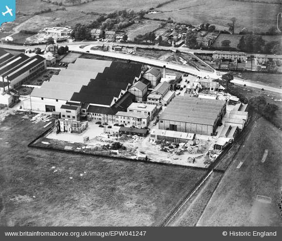
EPW041247 ENGLAND (1933). The British and Dominions Film Studios, Borehamwood, 1933
© Copyright OpenStreetMap contributors and licensed by the OpenStreetMap Foundation. 2026. Cartography is licensed as CC BY-SA.
Nearby Images (40)
Details
| Title | [EPW041247] The British and Dominions Film Studios, Borehamwood, 1933 |
| Reference | EPW041247 |
| Date | May-1933 |
| Link | |
| Place name | BOREHAMWOOD |
| Parish | ELSTREE AND BOREHAMWOOD |
| District | |
| Country | ENGLAND |
| Easting / Northing | 519915, 196887 |
| Longitude / Latitude | -0.26622644456164, 51.657495308254 |
| National Grid Reference | TQ199969 |
Pins
Be the first to add a comment to this image!


![[EPW041247] The British and Dominions Film Studios, Borehamwood, 1933](http://britainfromabove.org.uk/sites/all/libraries/aerofilms-images/public/100x100/EPW/041/EPW041247.jpg)
![[EAW027906] The Bullens Export Packing Depot along Elstree Way, Borehamwood, 1950. This image has been produced from a damaged negative.](http://britainfromabove.org.uk/sites/all/libraries/aerofilms-images/public/100x100/EAW/027/EAW027906.jpg)
![[EAW027904] The Bullens Export Packing Depot along Elstree Way, Borehamwood, 1950. This image has been produced from a damaged negative.](http://britainfromabove.org.uk/sites/all/libraries/aerofilms-images/public/100x100/EAW/027/EAW027904.jpg)
![[EAW027910] The Bullens Export Packing Depot along Elstree Way, Borehamwood, 1950. This image has been produced from a print marked by Aerofilms Ltd for photo editing.](http://britainfromabove.org.uk/sites/all/libraries/aerofilms-images/public/100x100/EAW/027/EAW027910.jpg)
![[EPW041242] The British and Dominions Film Studios, Borehamwood, 1933](http://britainfromabove.org.uk/sites/all/libraries/aerofilms-images/public/100x100/EPW/041/EPW041242.jpg)
![[EPW041248] The British and Dominions Film Studios, Borehamwood, 1933](http://britainfromabove.org.uk/sites/all/libraries/aerofilms-images/public/100x100/EPW/041/EPW041248.jpg)
![[EAW027907] The Bullens Export Packing Depot along Elstree Way, Borehamwood, 1950. This image has been produced from a damaged negative.](http://britainfromabove.org.uk/sites/all/libraries/aerofilms-images/public/100x100/EAW/027/EAW027907.jpg)
![[EAW027912] The Bullens Export Packing Depot along Elstree Way and environs, Borehamwood, 1950. This image has been produced from a print marked by Aerofilms Ltd for photo editing.](http://britainfromabove.org.uk/sites/all/libraries/aerofilms-images/public/100x100/EAW/027/EAW027912.jpg)
![[EAW027911] The Bullens Export Packing Depot along Elstree Way, Borehamwood, 1950. This image has been produced from a print marked by Aerofilms Ltd for photo editing.](http://britainfromabove.org.uk/sites/all/libraries/aerofilms-images/public/100x100/EAW/027/EAW027911.jpg)
![[EPW041246] The British and Dominions Film Studios, Borehamwood, 1933](http://britainfromabove.org.uk/sites/all/libraries/aerofilms-images/public/100x100/EPW/041/EPW041246.jpg)
![[EAW027905] The Bullens Export Packing Depot alongside Elstree Film Studios, Borehamwood, 1950. This image has been produced from a damaged negative.](http://britainfromabove.org.uk/sites/all/libraries/aerofilms-images/public/100x100/EAW/027/EAW027905.jpg)
![[EAW027908] The Bullens Export Packing Depot along Elstree Way, Borehamwood, 1950. This image has been produced from a print marked by Aerofilms Ltd for photo editing.](http://britainfromabove.org.uk/sites/all/libraries/aerofilms-images/public/100x100/EAW/027/EAW027908.jpg)
![[EPW041243] The British and Dominions Film Studios, Borehamwood, 1933](http://britainfromabove.org.uk/sites/all/libraries/aerofilms-images/public/100x100/EPW/041/EPW041243.jpg)
![[EAW027914] The Bullens Export Packing Depot along Elstree Way, Borehamwood, 1950. This image has been produced from a print marked by Aerofilms Ltd for photo editing.](http://britainfromabove.org.uk/sites/all/libraries/aerofilms-images/public/100x100/EAW/027/EAW027914.jpg)
![[EAW027909] The Bullens Export Packing Depot along Elstree Way, Borehamwood, 1950. This image has been produced from a print marked by Aerofilms Ltd for photo editing.](http://britainfromabove.org.uk/sites/all/libraries/aerofilms-images/public/100x100/EAW/027/EAW027909.jpg)
![[EPW041245] The British and Dominions Film Studios, Borehamwood, 1933](http://britainfromabove.org.uk/sites/all/libraries/aerofilms-images/public/100x100/EPW/041/EPW041245.jpg)
![[EPW041244] The British and Dominions Film Studios, Borehamwood, 1933](http://britainfromabove.org.uk/sites/all/libraries/aerofilms-images/public/100x100/EPW/041/EPW041244.jpg)
![[EAW027903] The Bullens Export Packing Depot along Elstree Way, Borehamwood, 1950. This image has been produced from a damaged negative.](http://britainfromabove.org.uk/sites/all/libraries/aerofilms-images/public/100x100/EAW/027/EAW027903.jpg)
![[EAW027913] The Bullens Export Packing Depot along Elstree Way, Borehamwood, 1950. This image has been produced from a print marked by Aerofilms Ltd for photo editing.](http://britainfromabove.org.uk/sites/all/libraries/aerofilms-images/public/100x100/EAW/027/EAW027913.jpg)
![[EAW023318] The British National Film Studios on Shenley Road, Borehamwood, from the east, 1949](http://britainfromabove.org.uk/sites/all/libraries/aerofilms-images/public/100x100/EAW/023/EAW023318.jpg)
![[EPW061089] The Associated British Picture Corporation Ltd (ABPC) Film Studios, Borehamwood, 1939](http://britainfromabove.org.uk/sites/all/libraries/aerofilms-images/public/100x100/EPW/061/EPW061089.jpg)
![[EPW025490] British International Pictures Film Studios, Borehamwood, 1928. This image has been produced from a damaged negative.](http://britainfromabove.org.uk/sites/all/libraries/aerofilms-images/public/100x100/EPW/025/EPW025490.jpg)
![[EAW023317] The British National Film Studios on Shenley Road, Borehamwood, from the east, 1949](http://britainfromabove.org.uk/sites/all/libraries/aerofilms-images/public/100x100/EAW/023/EAW023317.jpg)
![[EAW028292] Associated British Picture Corporation (ABPC) Studios on Shenley Road, Borehamwood, 1950](http://britainfromabove.org.uk/sites/all/libraries/aerofilms-images/public/100x100/EAW/028/EAW028292.jpg)
![[EAW028294] Associated British Picture Corporation (ABPC) Studios on Shenley Road, Borehamwood, 1950](http://britainfromabove.org.uk/sites/all/libraries/aerofilms-images/public/100x100/EAW/028/EAW028294.jpg)
![[EAW028073] The Associated British Picture Corporation Film Studios off Shenley Road, Borehamwood, 1950. This image has been produced from a print.](http://britainfromabove.org.uk/sites/all/libraries/aerofilms-images/public/100x100/EAW/028/EAW028073.jpg)
![[EAW028072] The Associated British Picture Corporation Film Studios off Shenley Road, Borehamwood, 1950. This image has been produced from a print.](http://britainfromabove.org.uk/sites/all/libraries/aerofilms-images/public/100x100/EAW/028/EAW028072.jpg)
![[EAW028289] Associated British Picture Corporation (ABPC) Studios on Shenley Road, Borehamwood, 1950](http://britainfromabove.org.uk/sites/all/libraries/aerofilms-images/public/100x100/EAW/028/EAW028289.jpg)
![[EPW021912] British International Pictures Ltd Film Studios, Borehamwood, 1928](http://britainfromabove.org.uk/sites/all/libraries/aerofilms-images/public/100x100/EPW/021/EPW021912.jpg)
![[EAW028075] The Associated British Picture Corporation Film Studios off Shenley Road, Borehamwood, 1950. This image has been produced from a print.](http://britainfromabove.org.uk/sites/all/libraries/aerofilms-images/public/100x100/EAW/028/EAW028075.jpg)
![[EAW028291] Associated British Picture Corporation (ABPC) Studios on Shenley Road, Borehamwood, 1950](http://britainfromabove.org.uk/sites/all/libraries/aerofilms-images/public/100x100/EAW/028/EAW028291.jpg)
![[EPW021913] British International Pictures Ltd Film Studios, Borehamwood, 1928](http://britainfromabove.org.uk/sites/all/libraries/aerofilms-images/public/100x100/EPW/021/EPW021913.jpg)
![[EAW028293] Associated British Picture Corporation (ABPC) Studios on Shenley Road, Borehamwood, 1950](http://britainfromabove.org.uk/sites/all/libraries/aerofilms-images/public/100x100/EAW/028/EAW028293.jpg)
![[EAW028071] The Associated British Picture Corporation Film Studios off Shenley Road, Borehamwood, 1950. This image has been produced from a print.](http://britainfromabove.org.uk/sites/all/libraries/aerofilms-images/public/100x100/EAW/028/EAW028071.jpg)
![[EPW025492] British International Pictures Film Studios, Borehamwood, 1928.](http://britainfromabove.org.uk/sites/all/libraries/aerofilms-images/public/100x100/EPW/025/EPW025492.jpg)
![[EPW025493] British International Pictures Film Studios, Borehamwood, 1928. This image has been produced from a copy-negative.](http://britainfromabove.org.uk/sites/all/libraries/aerofilms-images/public/100x100/EPW/025/EPW025493.jpg)
![[EPW046576] British International Pictures Ltd Film Studios on Shenley Road, Elstree, 1935](http://britainfromabove.org.uk/sites/all/libraries/aerofilms-images/public/100x100/EPW/046/EPW046576.jpg)
![[EPW021914] British International Pictures Ltd Film Studios, Borehamwood, 1928](http://britainfromabove.org.uk/sites/all/libraries/aerofilms-images/public/100x100/EPW/021/EPW021914.jpg)
![[EAW028070] The Associated British Picture Corporation Film Studios off Shenley Road, Borehamwood, 1950. This image has been produced from a print.](http://britainfromabove.org.uk/sites/all/libraries/aerofilms-images/public/100x100/EAW/028/EAW028070.jpg)
![[EAW028290] Associated British Picture Corporation (ABPC) Studios on Shenley Road, Borehamwood, 1950](http://britainfromabove.org.uk/sites/all/libraries/aerofilms-images/public/100x100/EAW/028/EAW028290.jpg)