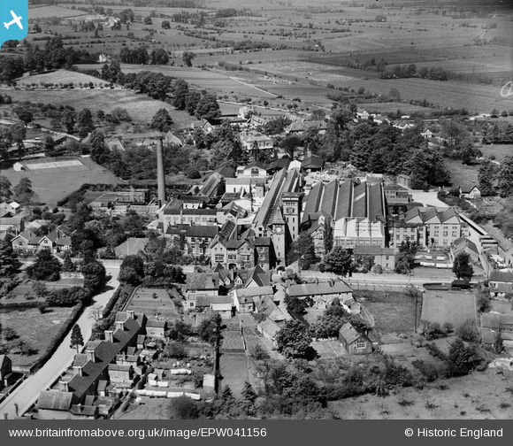
EPW041156 ENGLAND (1933). Clarks Boot and Shoe Factory, Street, 1933
© Copyright OpenStreetMap contributors and licensed by the OpenStreetMap Foundation. 2025. Cartography is licensed as CC BY-SA.
Nearby Images (21)
Details
| Title | [EPW041156] Clarks Boot and Shoe Factory, Street, 1933 |
| Reference | EPW041156 |
| Date | May-1933 |
| Link | |
| Place name | STREET |
| Parish | STREET |
| District | |
| Country | ENGLAND |
| Easting / Northing | 348421, 136855 |
| Longitude / Latitude | -2.7371687926764, 51.128122389193 |
| National Grid Reference | ST484369 |


![[EPW041156] Clarks Boot and Shoe Factory, Street, 1933](http://britainfromabove.org.uk/sites/all/libraries/aerofilms-images/public/100x100/EPW/041/EPW041156.jpg)
![[EAW043261] C. and J. Clark Ltd Shoe Factory, Street, 1952. This image has been produced from a print marked by Aerofilms Ltd for photo editing.](http://britainfromabove.org.uk/sites/all/libraries/aerofilms-images/public/100x100/EAW/043/EAW043261.jpg)
![[EPW041157] Clarks Boot and Shoe Factory, Street, 1933](http://britainfromabove.org.uk/sites/all/libraries/aerofilms-images/public/100x100/EPW/041/EPW041157.jpg)
![[EAW002953] C & J Clark Ltd Boot and Shoe Factory and environs, Street, 1946](http://britainfromabove.org.uk/sites/all/libraries/aerofilms-images/public/100x100/EAW/002/EAW002953.jpg)
![[EAW002952] C & J Clark Ltd Boot and Shoe Factory, Street, 1946](http://britainfromabove.org.uk/sites/all/libraries/aerofilms-images/public/100x100/EAW/002/EAW002952.jpg)
![[EPW041155] Clarks Boot and Shoe Factory, Street, 1933](http://britainfromabove.org.uk/sites/all/libraries/aerofilms-images/public/100x100/EPW/041/EPW041155.jpg)
![[EAW002957] C & J Clark Ltd Boot and Shoe Factory and the High Street, Street, 1946](http://britainfromabove.org.uk/sites/all/libraries/aerofilms-images/public/100x100/EAW/002/EAW002957.jpg)
![[EAW002950] C & J Clark Ltd Boot and Shoe Factory, Street, 1946](http://britainfromabove.org.uk/sites/all/libraries/aerofilms-images/public/100x100/EAW/002/EAW002950.jpg)
![[EAW002951] C & J Clark Ltd Boot and Shoe Factory, Street, 1946](http://britainfromabove.org.uk/sites/all/libraries/aerofilms-images/public/100x100/EAW/002/EAW002951.jpg)
![[EAW043259] C. and J. Clark Ltd Shoe Factory, Street, 1952. This image has been produced from a print marked by Aerofilms Ltd for photo editing.](http://britainfromabove.org.uk/sites/all/libraries/aerofilms-images/public/100x100/EAW/043/EAW043259.jpg)
![[EAW002956] C & J Clark Ltd Boot and Shoe Factory, Street, 1946](http://britainfromabove.org.uk/sites/all/libraries/aerofilms-images/public/100x100/EAW/002/EAW002956.jpg)
![[EAW043265] C. and J. Clark Ltd Shoe Factory, Street, 1952. This image has been produced from a print marked by Aerofilms Ltd for photo editing.](http://britainfromabove.org.uk/sites/all/libraries/aerofilms-images/public/100x100/EAW/043/EAW043265.jpg)
![[EAW002959] C & J Clark Ltd Boot and Shoe Factory and view to Glastonbury Tor, Street, from the south-west, 1946](http://britainfromabove.org.uk/sites/all/libraries/aerofilms-images/public/100x100/EAW/002/EAW002959.jpg)
![[EAW043260] C. and J. Clark Ltd Shoe Factory, Street, 1952. This image has been produced from a print marked by Aerofilms Ltd for photo editing.](http://britainfromabove.org.uk/sites/all/libraries/aerofilms-images/public/100x100/EAW/043/EAW043260.jpg)
![[EAW043262] C. and J. Clark Ltd Shoe Factory, Street, 1952. This image has been produced from a print marked by Aerofilms Ltd for photo editing.](http://britainfromabove.org.uk/sites/all/libraries/aerofilms-images/public/100x100/EAW/043/EAW043262.jpg)
![[EAW002954] C & J Clark Ltd Boot and Shoe Factory, Street, 1946](http://britainfromabove.org.uk/sites/all/libraries/aerofilms-images/public/100x100/EAW/002/EAW002954.jpg)
![[EAW002958] C & J Clark Ltd Boot and Shoe Factory and view to Glastonbury Tor, Street, from the south-west, 1946](http://britainfromabove.org.uk/sites/all/libraries/aerofilms-images/public/100x100/EAW/002/EAW002958.jpg)
![[EAW043266] C. and J. Clark Ltd Shoe Factory, Street, 1952. This image has been produced from a print.](http://britainfromabove.org.uk/sites/all/libraries/aerofilms-images/public/100x100/EAW/043/EAW043266.jpg)
![[EAW002955] C & J Clark Ltd Boot and Shoe Factory and environs, Street, 1946](http://britainfromabove.org.uk/sites/all/libraries/aerofilms-images/public/100x100/EAW/002/EAW002955.jpg)
![[EAW043264] C. and J. Clark Ltd Shoe Factory, Street, 1952. This image has been produced from a print.](http://britainfromabove.org.uk/sites/all/libraries/aerofilms-images/public/100x100/EAW/043/EAW043264.jpg)
![[EAW043263] C. and J. Clark Ltd Shoe Factory, Street, 1952. This image has been produced from a print marked by Aerofilms Ltd for photo editing.](http://britainfromabove.org.uk/sites/all/libraries/aerofilms-images/public/100x100/EAW/043/EAW043263.jpg)


