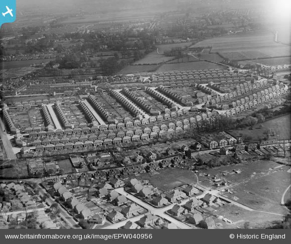
EPW040956 ENGLAND (1933). Housing surrounding Wood End Park Crescent and Wood End Park Road, Hayes, 1933
© Copyright OpenStreetMap contributors and licensed by the OpenStreetMap Foundation. 2026. Cartography is licensed as CC BY-SA.
Details
| Title | [EPW040956] Housing surrounding Wood End Park Crescent and Wood End Park Road, Hayes, 1933 |
| Reference | EPW040956 |
| Date | April-1933 |
| Link | |
| Place name | HAYES |
| Parish | |
| District | |
| Country | ENGLAND |
| Easting / Northing | 508378, 181372 |
| Longitude / Latitude | -0.43775391701823, 51.5203742989 |
| National Grid Reference | TQ084814 |
Pins

bmwtouring |
Thursday 29th of March 2018 03:53:42 PM | |

outdoorsweeper |
Saturday 10th of October 2015 10:22:45 PM | |

outdoorsweeper |
Saturday 10th of October 2015 10:22:45 PM | |

outdoorsweeper |
Saturday 10th of October 2015 10:22:45 PM | |

outdoorsweeper |
Saturday 10th of October 2015 10:22:43 PM | |

outdoorsweeper |
Saturday 10th of October 2015 10:22:41 PM | |

JamesD |
Sunday 16th of November 2014 10:42:20 PM | |

JamesD |
Sunday 16th of November 2014 10:41:40 PM |


![[EPW040956] Housing surrounding Wood End Park Crescent and Wood End Park Road, Hayes, 1933](http://britainfromabove.org.uk/sites/all/libraries/aerofilms-images/public/100x100/EPW/040/EPW040956.jpg)
![[EPW031279] Wood End Green and environs, Hayes, 1930](http://britainfromabove.org.uk/sites/all/libraries/aerofilms-images/public/100x100/EPW/031/EPW031279.jpg)
![[EPW031280] Wood End Green and environs, Hayes, 1930](http://britainfromabove.org.uk/sites/all/libraries/aerofilms-images/public/100x100/EPW/031/EPW031280.jpg)


