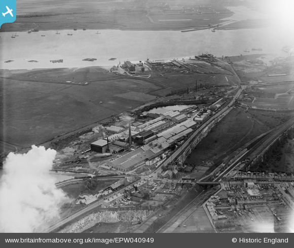
EPW040949 ENGLAND (1933). The British Vegetable Parchment Mills, the New Northfleet Paper Mills and the River Thames, Swanscombe, 1933
© Copyright OpenStreetMap contributors and licensed by the OpenStreetMap Foundation. 2026. Cartography is licensed as CC BY-SA.
Nearby Images (22)
Details
| Title | [EPW040949] The British Vegetable Parchment Mills, the New Northfleet Paper Mills and the River Thames, Swanscombe, 1933 |
| Reference | EPW040949 |
| Date | April-1933 |
| Link | |
| Place name | SWANSCOMBE |
| Parish | SWANSCOMBE AND GREENHITHE |
| District | |
| Country | ENGLAND |
| Easting / Northing | 560937, 175060 |
| Longitude / Latitude | 0.31643787938451, 51.451130368984 |
| National Grid Reference | TQ609751 |
Pins
Be the first to add a comment to this image!


![[EPW040949] The British Vegetable Parchment Mills, the New Northfleet Paper Mills and the River Thames, Swanscombe, 1933](http://britainfromabove.org.uk/sites/all/libraries/aerofilms-images/public/100x100/EPW/040/EPW040949.jpg)
![[EPW018631] The New Northfleet Paper Mills, Swanscombe, 1927](http://britainfromabove.org.uk/sites/all/libraries/aerofilms-images/public/100x100/EPW/018/EPW018631.jpg)
![[EPW040725] The High Street and paper mills beside Galley Hill Road, Swanscombe, 1932](http://britainfromabove.org.uk/sites/all/libraries/aerofilms-images/public/100x100/EPW/040/EPW040725.jpg)
![[EPW018630] The New Northfleet Paper Mills, Swanscombe, 1927](http://britainfromabove.org.uk/sites/all/libraries/aerofilms-images/public/100x100/EPW/018/EPW018630.jpg)
![[EPW040720] The High Street and paper mills beside Galley Hill Road, Swanscombe, 1932](http://britainfromabove.org.uk/sites/all/libraries/aerofilms-images/public/100x100/EPW/040/EPW040720.jpg)
![[EAW050796] The New Northfleet Paper Mills, British Vegetable Parchment Mills and Kent Kraft Paper Sack Mills, Swanscombe, 1953. This image was marked by Aerofilms Ltd for photo editing.](http://britainfromabove.org.uk/sites/all/libraries/aerofilms-images/public/100x100/EAW/050/EAW050796.jpg)
![[EPW040947] All Saints' Church, the British Vegetable Parchment Mills and the New Northfleet Paper Mills, Swanscombe, 1933](http://britainfromabove.org.uk/sites/all/libraries/aerofilms-images/public/100x100/EPW/040/EPW040947.jpg)
![[EPW028498] New Northfleet Paper Mills, British Vegetable Parchment Mills and Kent Kraft Mills, Swanscombe, 1929](http://britainfromabove.org.uk/sites/all/libraries/aerofilms-images/public/100x100/EPW/028/EPW028498.jpg)
![[EPW040724] The New Northfleet Paper Mills, British Vegetable Parchment Mills and Kent Kraft Paper Sack Mills, Swanscombe, 1932](http://britainfromabove.org.uk/sites/all/libraries/aerofilms-images/public/100x100/EPW/040/EPW040724.jpg)
![[EPW040951] The British Vegetable Parchment Mills, the Kent Kraft Mills and the New Northfleet Paper Mills, Swanscombe, 1933. This image has been affected by flare.](http://britainfromabove.org.uk/sites/all/libraries/aerofilms-images/public/100x100/EPW/040/EPW040951.jpg)
![[EPW040721] The New Northfleet Paper Mills, British Vegetable Parchment Mills and Kent Kraft Paper Sack Mills, Swanscombe, 1932](http://britainfromabove.org.uk/sites/all/libraries/aerofilms-images/public/100x100/EPW/040/EPW040721.jpg)
![[EPW040732] The New Northfleet Paper Mills, British Vegetable Parchment Mills and Kent Kraft Paper Sack Mills, Swanscombe, 1932](http://britainfromabove.org.uk/sites/all/libraries/aerofilms-images/public/100x100/EPW/040/EPW040732.jpg)
![[EPW028506] The New Northfleet Paper Mills, British Vegetable Parchment Mills and Kent Kraft Mills, Swanscombe, 1929](http://britainfromabove.org.uk/sites/all/libraries/aerofilms-images/public/100x100/EPW/028/EPW028506.jpg)
![[EPW040948] The British Vegetable Parchment Mills, the Kent Kraft Mills and the New Northfleet Paper Mills, Swanscombe, 1933](http://britainfromabove.org.uk/sites/all/libraries/aerofilms-images/public/100x100/EPW/040/EPW040948.jpg)
![[EAW050800] The New Northfleet Paper Mills, British Vegetable Parchment Mills and Kent Kraft Paper Sack Mills, Swanscombe, 1953. This image was marked by Aerofilms Ltd for photo editing.](http://britainfromabove.org.uk/sites/all/libraries/aerofilms-images/public/100x100/EAW/050/EAW050800.jpg)
![[EAW050798] The New Northfleet Paper Mills, British Vegetable Parchment Mills and Kent Kraft Paper Sack Mills, Swanscombe, 1953. This image was marked by Aerofilms Ltd for photo editing.](http://britainfromabove.org.uk/sites/all/libraries/aerofilms-images/public/100x100/EAW/050/EAW050798.jpg)
![[EAW050799] The New Northfleet Paper Mills, British Vegetable Parchment Mills and Kent Kraft Paper Sack Mills, Swanscombe, 1953. This image was marked by Aerofilms Ltd for photo editing.](http://britainfromabove.org.uk/sites/all/libraries/aerofilms-images/public/100x100/EAW/050/EAW050799.jpg)
![[EAW050801] The New Northfleet Paper Mills, British Vegetable Parchment Mills and Kent Kraft Paper Sack Mills, Swanscombe, 1953. This image was marked by Aerofilms Ltd for photo editing.](http://britainfromabove.org.uk/sites/all/libraries/aerofilms-images/public/100x100/EAW/050/EAW050801.jpg)
![[EAW050802] The New Northfleet Paper Mills, British Vegetable Parchment Mills and Kent Kraft Paper Sack Mills, Swanscombe, 1953. This image was marked by Aerofilms Ltd for photo editing.](http://britainfromabove.org.uk/sites/all/libraries/aerofilms-images/public/100x100/EAW/050/EAW050802.jpg)
![[EAW050797] The New Northfleet Paper Mills, British Vegetable Parchment Mills and Kent Kraft Paper Sack Mills, Swanscombe, 1953. This image was marked by Aerofilms Ltd for photo editing.](http://britainfromabove.org.uk/sites/all/libraries/aerofilms-images/public/100x100/EAW/050/EAW050797.jpg)
![[EPW028502] New Northfleet Paper Mills, British Vegetable Parchment Mills and Kent Kraft Mills, Swanscombe, 1929](http://britainfromabove.org.uk/sites/all/libraries/aerofilms-images/public/100x100/EPW/028/EPW028502.jpg)
![[EAW050793] The New Northfleet Paper Mills, British Vegetable Parchment Mills and Kent Kraft Paper Sack Mills, Swanscombe, from the south-west, 1953. This image was marked by Aerofilms Ltd for photo editing.](http://britainfromabove.org.uk/sites/all/libraries/aerofilms-images/public/100x100/EAW/050/EAW050793.jpg)