
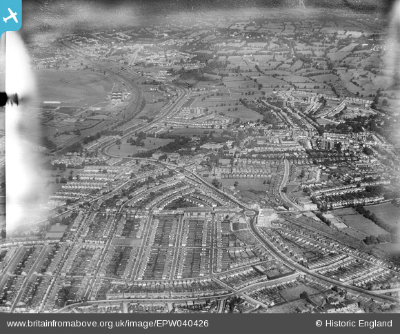
EPW040426 ENGLAND (1932). Housing development around Hendon Central, Hendon, from the south, 1932
© Copyright OpenStreetMap contributors and licensed by the OpenStreetMap Foundation. 2026. Cartography is licensed as CC BY-SA.
Nearby Images (18)
EPW040426

EPW040429

EPW040432

EPW040427

EPW040428

EPW031655

EPW040431

EPW040430

EPR000516

EPW016520

EPW010014

EPW009537

EPW009348

EPW038717

EPW016522

EPW031652

EPW050374

EPW050378

Details
| Title | [EPW040426] Housing development around Hendon Central, Hendon, from the south, 1932 |
| Reference | EPW040426 |
| Date | September-1932 |
| Link | |
| Place name | HENDON |
| Parish | |
| District | |
| Country | ENGLAND |
| Easting / Northing | 522838, 188350 |
| Longitude / Latitude | -0.22697980856003, 51.580133363399 |
| National Grid Reference | TQ228884 |
Pins
Be the first to add a comment to this image!
User Comment Contributions
Comparing the same area / photo in the 1926 photo to this one just six or seven years later its amazing to see the difference in the amount of housing built between those two dates. I bet they would be hard pushed to surpass that today with the planning system as it is in 2016. Those roads are my childhood cycle routes as a greengrocers delivery boy working out of the shop next to ABC bakers in Vivian Avenue. What wonderful memories this photo brings back of the early 1960's. Not a care in the world. |

NthLondonBoy |
Saturday 3rd of September 2016 05:31:28 PM |