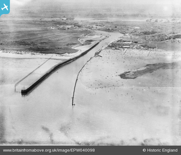
EPW040098 ENGLAND (1932). The entrance to Littlehampton Harbour, Littlehampton, from the south-east, 1932
    © Copyright OpenStreetMap contributors and licensed by the OpenStreetMap Foundation. 2025. Cartography is licensed as CC BY-SA.
  
Details
| Title | [EPW040098] The entrance to Littlehampton Harbour, Littlehampton, from the south-east, 1932 | 
| Reference | EPW040098 | 
| Date | August-1932 | 
| Link | |
| Place name | LITTLEHAMPTON | 
| Parish | LITTLEHAMPTON | 
| District | |
| Country | ENGLAND | 
| Easting / Northing | 503055, 100875 | 
| Longitude / Latitude | -0.53752186132416, 50.797698569301 | 
| National Grid Reference | TQ031009 | 
Pins
|  Remains of Littlehampton fort. |   paul | Saturday 6th of May 2017 03:42:06 PM | 
 
             
  ![[EPW040098] The entrance to Littlehampton Harbour, Littlehampton, from the south-east, 1932](http://britainfromabove.org.uk/sites/all/libraries/aerofilms-images/public/100x100/EPW/040/EPW040098.jpg) 
  
                                          ![[EPW039466] The mouth of the River Arun, the town and the seafront, Littlehampton, from the south, 1932](http://britainfromabove.org.uk/sites/all/libraries/aerofilms-images/public/100x100/EPW/039/EPW039466.jpg) 
 ![[EAW012237] The town and surrounding countryside at Poling and Arundel, Littlehampton, from the south, 1947. This image was marked by Aerofilms Ltd for photo editing.](http://britainfromabove.org.uk/sites/all/libraries/aerofilms-images/public/100x100/EAW/012/EAW012237.jpg)