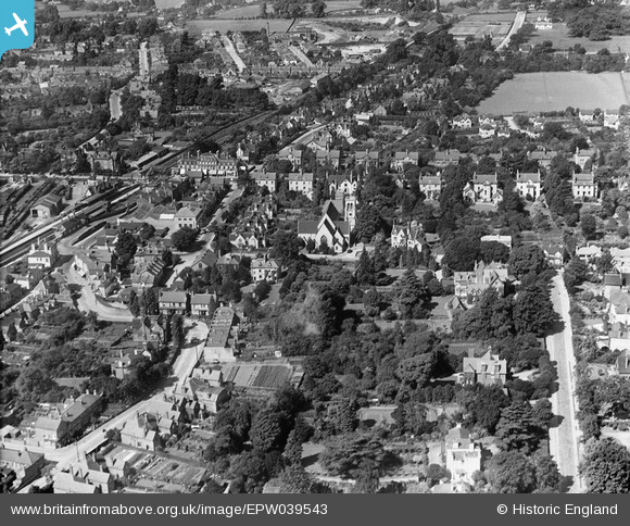
EPW039543 ENGLAND (1932). Reigate Railway Station, St Mark's Church and environs, Reigate, 1932
© Copyright OpenStreetMap contributors and licensed by the OpenStreetMap Foundation. 2026. Cartography is licensed as CC BY-SA.
Details
| Title | [EPW039543] Reigate Railway Station, St Mark's Church and environs, Reigate, 1932 |
| Reference | EPW039543 |
| Date | August-1932 |
| Link | |
| Place name | REIGATE |
| Parish | |
| District | |
| Country | ENGLAND |
| Easting / Northing | 525528, 150866 |
| Longitude / Latitude | -0.20144571282991, 51.242627771759 |
| National Grid Reference | TQ255509 |
Pins

David960 |
Friday 13th of February 2015 07:02:24 PM | |

Class31 |
Wednesday 5th of March 2014 10:35:12 AM | |

Class31 |
Wednesday 5th of March 2014 10:34:27 AM | |

Class31 |
Wednesday 5th of March 2014 10:32:56 AM | |

Class31 |
Wednesday 5th of March 2014 10:31:16 AM | |

Class31 |
Wednesday 5th of March 2014 10:30:48 AM | |

Class31 |
Wednesday 5th of March 2014 10:29:51 AM | |

Class31 |
Wednesday 5th of March 2014 10:29:24 AM | |

Class31 |
Wednesday 5th of March 2014 10:28:51 AM |
User Comment Contributions
View looking west. |

Class31 |
Wednesday 5th of March 2014 10:35:30 AM |


![[EPW039543] Reigate Railway Station, St Mark's Church and environs, Reigate, 1932](http://britainfromabove.org.uk/sites/all/libraries/aerofilms-images/public/100x100/EPW/039/EPW039543.jpg)
![[EPW025256] The railway station, St Mark's Church and environs, Reigate, 1928. This image has been produced from a damaged negative.](http://britainfromabove.org.uk/sites/all/libraries/aerofilms-images/public/100x100/EPW/025/EPW025256.jpg)
![[EPW039546] Housing surrounding Reigatehill Road and St Albans Road, Reigate, 1932](http://britainfromabove.org.uk/sites/all/libraries/aerofilms-images/public/100x100/EPW/039/EPW039546.jpg)