
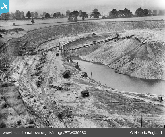
EPW039080 ENGLAND (1932). Quarry belonging to the Southam Cement Works, Long Itchington, 1932
© Copyright OpenStreetMap contributors and licensed by the OpenStreetMap Foundation. 2026. Cartography is licensed as CC BY-SA.
Nearby Images (2)
EPW039080

EPW039079

Details
| Title | [EPW039080] Quarry belonging to the Southam Cement Works, Long Itchington, 1932 |
| Reference | EPW039080 |
| Date | July-1932 |
| Link | |
| Place name | LONG ITCHINGTON |
| Parish | LONG ITCHINGTON |
| District | |
| Country | ENGLAND |
| Easting / Northing | 442064, 263566 |
| Longitude / Latitude | -1.3835201370564, 52.268247098132 |
| National Grid Reference | SP421636 |
Pins

Dylan Moore |
Sunday 31st of July 2016 11:28:48 AM | |

MB |
Saturday 15th of December 2012 06:38:55 PM | |
All track work within such a place as this is "temporary". It's moved to keep up with the face of the quarry. Also note that the track seems to be in straight sections, which are curved on site to requirements. |
John Wass |
Saturday 10th of March 2018 09:40:06 PM |
|
Dylan Moore |
Monday 10th of December 2012 09:18:51 PM | |
|
Dylan Moore |
Monday 10th of December 2012 09:18:13 PM | |
|
Dylan Moore |
Monday 10th of December 2012 09:17:57 PM |
User Comment Contributions
The raw material is Blue Lias, consisting of alternating layers of argillaceous limestone and calcareous shale. All the limestone and a little of the shale were used to make cement rawmix, but most of the shale was discarded. The mixture of rock could be separated on a rotary screen, since the shale was soft and would fall through. The waste shale was then stacked in a worked-out part of the deposit. |
Dylan Moore |
Monday 10th of December 2012 09:24:01 PM |