
EPW039028 ENGLAND (1932). Terry's Chocolate Factory and environs, York, from the south-east, 1932

© Copyright OpenStreetMap contributors and licensed by the OpenStreetMap Foundation. 2026. Cartography is licensed as CC BY-SA.
Nearby Images (14)
EPW039028

EPW039027

EPW039029

EPW039025

EPW039032

EPW039030

EPW017227

EPW039033

EPW039034

EPW039031

EPW017228

EPW039026

EPW017226

EPW016068
, York, 1926")
Details
| Title | [EPW039028] Terry's Chocolate Factory and environs, York, from the south-east, 1932 |
| Reference | EPW039028 |
| Date | July-1932 |
| Link | |
| Place name | YORK |
| Parish | |
| District | |
| Country | ENGLAND |
| Easting / Northing | 460024, 449625 |
| Longitude / Latitude | -1.085530567489, 53.939056798606 |
| National Grid Reference | SE600496 |
Pins

Class31 |
Wednesday 23rd of January 2013 04:35:11 PM |
User Comment Contributions

Terry's Chocolate Factory, York, 28/08/2014 |
Class31 |
Tuesday 16th of September 2014 10:20:08 AM |
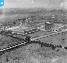
Terry's with Campleshon Road and the streets running off it in the background, 1932 |

YorkStories |
Thursday 16th of May 2013 10:00:27 PM |
Terry's with Campleshon Road and the streets running off it in the background. |
YorkStories |
Thursday 16th of May 2013 05:18:33 PM |