
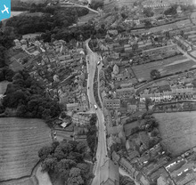
EPW038921 ENGLAND (1932). The High Street and town centre, Loftus, 1932

© Copyright OpenStreetMap contributors and licensed by the OpenStreetMap Foundation. 2026. Cartography is licensed as CC BY-SA.
Nearby Images (3)
EPW038921

EPW029108

EPW029109

Details
| Title | [EPW038921] The High Street and town centre, Loftus, 1932 |
| Reference | EPW038921 |
| Date | July-1932 |
| Link | |
| Place name | LOFTUS |
| Parish | LOFTUS |
| District | |
| Country | ENGLAND |
| Easting / Northing | 472347, 518200 |
| Longitude / Latitude | -0.8812713864832, 54.553740769145 |
| National Grid Reference | NZ723182 |
Pins
Be the first to add a comment to this image!
User Comment Contributions
The High Street and town centre, Loftus, 1932 |

Ali |
Sunday 20th of January 2013 07:41:32 PM |