
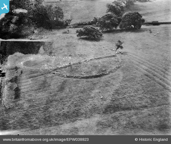
EPW038823 ENGLAND (1932). Earthworks in Wennington Park, Wennington, 1932
© Copyright OpenStreetMap contributors and licensed by the OpenStreetMap Foundation. 2026. Cartography is licensed as CC BY-SA.
Nearby Images (3)
EPW038823

EPW038821

EPW038822

Details
| Title | [EPW038823] Earthworks in Wennington Park, Wennington, 1932 |
| Reference | EPW038823 |
| Date | 30-June-1932 |
| Link | |
| Place name | WENNINGTON |
| Parish | WENNINGTON |
| District | |
| Country | ENGLAND |
| Easting / Northing | 361761, 470500 |
| Longitude / Latitude | -2.5852271359374, 54.12875333713 |
| National Grid Reference | SD618705 |
Pins
Be the first to add a comment to this image!
User Comment Contributions
Hi Dylan, Great spot! Thank you, this and the two other images of the earthwork are really tricky so it's great to have them identified. The original Aerofilms Ltd Register entry is "Wellington". Close, but not close enough, to the actual place name! We'll update the catalogue entry, and post the new data here in due course. Yours, Katy Britain from Above Cataloguing Team Leader |
Katy Whitaker |
Friday 8th of March 2013 03:21:39 PM |
Wennington Hall, Lancs. A faint boundary bank passing across the earthwork was not on contemporary maps, but is now re-established. Unfortunately the earthwork does not appear on any map edition that I have seen. However, the location is established unambiguously by the structure of the nearby walled garden, with a D-shaped extension on the southern wall. A glasshouse is seen within this in the picture, and is shown in the contemporary (1913 & 1894) 1:2500 OS maps. |

Dylan Moore |
Monday 25th of February 2013 02:08:42 PM |
again possibly Ditton/Ditchfield Road area of Widnes with housing development now covering it, it was reported at the time but NO archaeological report at time of building, housing only started after the war, prefab then council housing |

Beverley |
Friday 8th of February 2013 01:46:14 PM |
Appears to be a different angle of Photo EPW038821. |
TheBlueCube |
Wednesday 23rd of January 2013 07:34:32 PM |
Looks like a henge monument or a causewayed enclosure (both Neolithic monuments in date). If it is, it should be easy enough to identify with the ridge and furrow respecting it and the later earthwork bisecting it. |
Rebecca |
Wednesday 9th of January 2013 10:47:56 AM |
Don't know location but this is same as EPW038821 - note the ridge and position of solitary shrub and nearby tree. |

Mike Dean |
Wednesday 12th of December 2012 10:35:34 PM |