
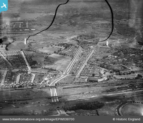
EPW038700 ENGLAND (1932). Brent Junction and housing off the North Circular Road, Stonebridge, from the south-west, 1932. This image has been produced from a damaged negative.
© Copyright OpenStreetMap contributors and licensed by the OpenStreetMap Foundation. 2026. Cartography is licensed as CC BY-SA.
Nearby Images (2)
EPW038700

EPW038701

Details
| Title | [EPW038700] Brent Junction and housing off the North Circular Road, Stonebridge, from the south-west, 1932. This image has been produced from a damaged negative. |
| Reference | EPW038700 |
| Date | June-1932 |
| Link | |
| Place name | STONEBRIDGE |
| Parish | |
| District | |
| Country | ENGLAND |
| Easting / Northing | 519856, 184122 |
| Longitude / Latitude | -0.27144188662217, 51.542772923531 |
| National Grid Reference | TQ199841 |
Pins

John Wass |
Friday 2nd of February 2018 07:44:31 PM | |
|
steve |
Thursday 24th of March 2016 04:36:41 PM | |
|
Wilmington |
Friday 21st of February 2014 01:30:33 AM | |
|
Wilmington |
Friday 17th of January 2014 12:46:45 PM | |

greenchief |
Wednesday 18th of December 2013 10:41:19 AM | |
|
greenchief |
Wednesday 24th of July 2013 02:16:33 PM | |
|
greenchief |
Wednesday 24th of July 2013 02:14:17 PM | |
|
greenchief |
Wednesday 24th of July 2013 02:13:01 PM | |
|
greenchief |
Wednesday 24th of July 2013 02:10:49 PM | |
|
classicforever |
Sunday 30th of December 2012 08:31:39 AM | |
|
classicforever |
Sunday 30th of December 2012 08:29:25 AM | |
|
classicforever |
Sunday 30th of December 2012 08:21:25 AM | |
I think the N C Rd may have been opened in 1934. So this section although ready, carried no traffic. |
Harrow&Wembley |
Saturday 1st of November 2014 01:53:32 PM |
|
classicforever |
Sunday 30th of December 2012 08:19:21 AM | |
|
classicforever |
Sunday 30th of December 2012 08:18:07 AM | |
|
classicforever |
Sunday 30th of December 2012 08:16:03 AM | |
|
classicforever |
Sunday 30th of December 2012 08:15:26 AM | |
|
classicforever |
Sunday 30th of December 2012 08:14:41 AM | |
|
classicforever |
Sunday 30th of December 2012 08:13:34 AM | |
|
classicforever |
Saturday 29th of December 2012 02:14:06 PM | |
|
greenchief |
Wednesday 19th of December 2012 12:38:50 PM | |
|
greenchief |
Wednesday 19th of December 2012 12:36:22 PM | |
|
greenchief |
Wednesday 19th of December 2012 12:34:31 PM | |
|
greenchief |
Wednesday 19th of December 2012 12:32:29 PM | |
Not to be too pedantic but the correct term is "hump" not ramp. |
John Wass |
Friday 3rd of November 2017 02:51:52 PM |
|
greenchief |
Wednesday 19th of December 2012 12:29:06 PM | |
Opened in 1906 by the Metropilitan Electric Tramway [MET] company to serve their new tramway between Harlesden High Street and Stonebridge Park. To accommodate the trolleybuses when they replaced the trams from 5th july 1936 the depot was enlarged and rebuilt for through running. London Transport had a trolleybus driver training school here with a wired circuit around the perimeter of the depot, and a simulator in the classroom. Stonebridge was one of the depots which operated Class C2 buses which were distinguished by the 'spats' over the rear wheels. On 2nd January 1962 as part of stage 13 of the conversion plan Stonebridge went over to diesel buses, so the tram shed which became a trolleybus depot was now a bus garage. |
Nowy Paul |
Saturday 6th of January 2018 03:06:20 PM |
|
greenchief |
Wednesday 19th of December 2012 12:26:48 PM | |
|
greenchief |
Wednesday 19th of December 2012 12:25:13 PM | |
|
greenchief |
Wednesday 19th of December 2012 12:23:17 PM | |
|
greenchief |
Wednesday 19th of December 2012 12:21:37 PM | |
|
greenchief |
Wednesday 19th of December 2012 12:20:33 PM | |
|
greenchief |
Wednesday 19th of December 2012 12:19:43 PM | |
|
greenchief |
Wednesday 19th of December 2012 12:17:23 PM |

User Comment Contributions

Stonebridge Estate looking North |
classicforever |
Sunday 30th of December 2012 08:08:44 AM |