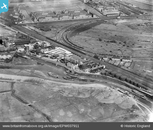
EPW037911 ENGLAND (1932). The Redline-Glico Works and Upper Abbey Mills Junction, Mill Meads, 1932
© Copyright OpenStreetMap contributors and licensed by the OpenStreetMap Foundation. 2026. Cartography is licensed as CC BY-SA.
Nearby Images (14)
Details
| Title | [EPW037911] The Redline-Glico Works and Upper Abbey Mills Junction, Mill Meads, 1932 |
| Reference | EPW037911 |
| Date | 18-May-1932 |
| Link | |
| Place name | MILL MEADS |
| Parish | |
| District | |
| Country | ENGLAND |
| Easting / Northing | 538752, 182830 |
| Longitude / Latitude | 0.0003995854110057, 51.526832083586 |
| National Grid Reference | TQ388828 |
Pins

John W |
Monday 27th of March 2017 04:58:53 PM | |

John W |
Monday 27th of March 2017 04:55:54 PM | |

John W |
Monday 27th of March 2017 04:55:03 PM |


![[EPW037911] The Redline-Glico Works and Upper Abbey Mills Junction, Mill Meads, 1932](http://britainfromabove.org.uk/sites/all/libraries/aerofilms-images/public/100x100/EPW/037/EPW037911.jpg)
![[EPW037917] The Redline-Glico Works and Upper Abbey Mills Junction, Mill Meads, 1932](http://britainfromabove.org.uk/sites/all/libraries/aerofilms-images/public/100x100/EPW/037/EPW037917.jpg)
![[EPW037914] The Redline-Glico Works and Upper Abbey Mills Junction, Mill Meads, 1932](http://britainfromabove.org.uk/sites/all/libraries/aerofilms-images/public/100x100/EPW/037/EPW037914.jpg)
![[EPW037916] The Redline-Glico Works and Upper Abbey Mills Junction, Mill Meads, 1932](http://britainfromabove.org.uk/sites/all/libraries/aerofilms-images/public/100x100/EPW/037/EPW037916.jpg)
![[EPW037915] The Redline-Glico Works and Upper Abbey Mills Junction, Mill Meads, 1932](http://britainfromabove.org.uk/sites/all/libraries/aerofilms-images/public/100x100/EPW/037/EPW037915.jpg)
![[EPW037912] The Redline-Glico Works and Upper Abbey Mills Junction, Mill Meads, 1932](http://britainfromabove.org.uk/sites/all/libraries/aerofilms-images/public/100x100/EPW/037/EPW037912.jpg)
![[EPW037913] The Redline-Glico Works and Upper Abbey Mills Junction, Mill Meads, 1932](http://britainfromabove.org.uk/sites/all/libraries/aerofilms-images/public/100x100/EPW/037/EPW037913.jpg)
![[EPW009742A] Abbey Mills Chemical Works, Mill Meads, 1923](http://britainfromabove.org.uk/sites/all/libraries/aerofilms-images/public/100x100/EPW/009/EPW009742A.jpg)
![[EPW009737] Abbey Mills Chemical Works, Mill Meads, 1923](http://britainfromabove.org.uk/sites/all/libraries/aerofilms-images/public/100x100/EPW/009/EPW009737.jpg)
![[EPW009738] Abbey Mills Chemical Works, Mill Meads, 1923](http://britainfromabove.org.uk/sites/all/libraries/aerofilms-images/public/100x100/EPW/009/EPW009738.jpg)
![[EPW009740] Abbey Mills Chemical Works, Mill Meads, 1923](http://britainfromabove.org.uk/sites/all/libraries/aerofilms-images/public/100x100/EPW/009/EPW009740.jpg)
![[EPW009739] Abbey Mills Chemical Works, Mill Meads, 1923](http://britainfromabove.org.uk/sites/all/libraries/aerofilms-images/public/100x100/EPW/009/EPW009739.jpg)
![[EPW009741] Abbey Mills Chemical Works, Mill Meads, 1923](http://britainfromabove.org.uk/sites/all/libraries/aerofilms-images/public/100x100/EPW/009/EPW009741.jpg)
![[EPW009705] Abbey Mills Chemical Works, Mill Meads, 1923](http://britainfromabove.org.uk/sites/all/libraries/aerofilms-images/public/100x100/EPW/009/EPW009705.jpg)