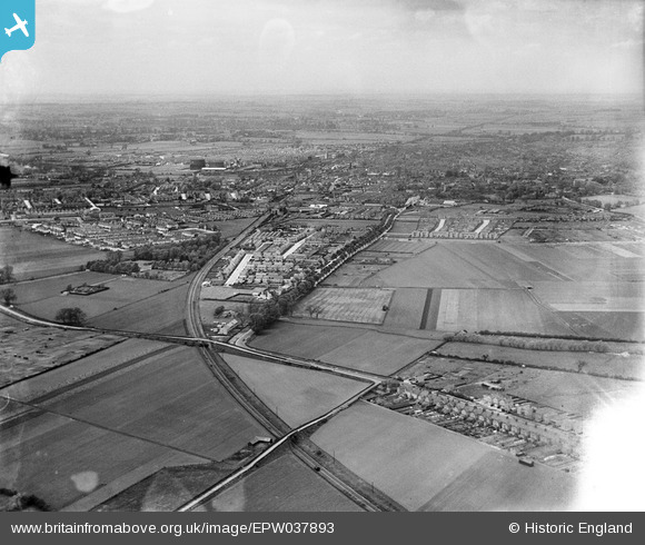
EPW037893 ENGLAND (1932). Mile Road crossing the Leicester Bedford and Hitchin Railway, the town and surrounding countryside, Bedford, from the south-east, 1932
© Copyright OpenStreetMap contributors and licensed by the OpenStreetMap Foundation. 2026. Cartography is licensed as CC BY-SA.
Details
| Title | [EPW037893] Mile Road crossing the Leicester Bedford and Hitchin Railway, the town and surrounding countryside, Bedford, from the south-east, 1932 |
| Reference | EPW037893 |
| Date | May-1932 |
| Link | |
| Place name | BEDFORD |
| Parish | |
| District | |
| Country | ENGLAND |
| Easting / Northing | 506249, 247979 |
| Longitude / Latitude | -0.44799017169184, 52.119493066226 |
| National Grid Reference | TL062480 |
Pins

Barney |
Friday 28th of February 2020 01:19:50 PM | |

Barney |
Friday 28th of February 2020 01:13:45 PM | |

Barney |
Friday 28th of February 2020 01:13:13 PM | |

Barney |
Friday 28th of February 2020 01:12:45 PM | |

Barney |
Friday 28th of February 2020 01:12:18 PM | |

Barney |
Friday 28th of February 2020 01:11:58 PM | |

John Wass |
Wednesday 10th of June 2015 09:16:45 PM |
User Comment Contributions
See also image EPW037894. |

melgibbs |
Tuesday 14th of January 2014 08:23:46 PM |


![[EPW037893] Mile Road crossing the Leicester Bedford and Hitchin Railway, the town and surrounding countryside, Bedford, from the south-east, 1932](http://britainfromabove.org.uk/sites/all/libraries/aerofilms-images/public/100x100/EPW/037/EPW037893.jpg)
![[EPW037894] Mile Road crossing the Leicester Bedford and Hitchin Railway, the town and surrounding countryside, Bedford, from the south-east, 1932](http://britainfromabove.org.uk/sites/all/libraries/aerofilms-images/public/100x100/EPW/037/EPW037894.jpg)
![[EPW037889] Mile Road crossing the Leicester Bedford and Hitchin Railway, the town and surrounding countryside, Bedford, from the south-east, 1932](http://britainfromabove.org.uk/sites/all/libraries/aerofilms-images/public/100x100/EPW/037/EPW037889.jpg)