
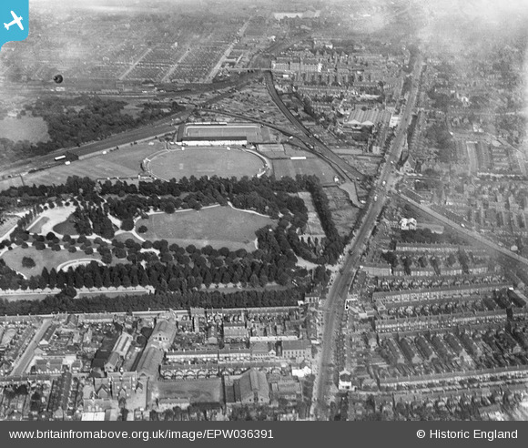
EPW036391 ENGLAND (1931). West Park, The Circle Cricket Ground and Anlaby Road Football Ground, Kingston upon Hull, 1931
© Copyright OpenStreetMap contributors and licensed by the OpenStreetMap Foundation. 2025. Cartography is licensed as CC BY-SA.
Nearby Images (7)
EPW036391

EPW012816

EPW036568

EPW036556

EPW012821

EPW036553

EPW036552

Details
| Title | [EPW036391] West Park, The Circle Cricket Ground and Anlaby Road Football Ground, Kingston upon Hull, 1931 |
| Reference | EPW036391 |
| Date | August-1931 |
| Link | |
| Place name | KINGSTON UPON HULL |
| Parish | |
| District | |
| Country | ENGLAND |
| Easting / Northing | 507620, 428826 |
| Longitude / Latitude | -0.36794225477192, 53.744464901825 |
| National Grid Reference | TA076288 |
Pins

Starman |
Saturday 21st of March 2020 08:06:30 PM | |
|
Starman |
Saturday 21st of March 2020 08:05:43 PM | |
Yes, The Circle. Also I believe used by Hull & East Riding rugby union club at one time. |
gerry-r |
Saturday 10th of August 2024 03:55:39 PM |
|
John Wass |
Monday 3rd of July 2017 03:54:26 PM | |
|
John Wass |
Monday 3rd of July 2017 03:53:28 PM | |
|
John Wass |
Monday 3rd of July 2017 03:51:56 PM | |
|
John Wass |
Monday 3rd of July 2017 03:51:15 PM | |
|
John Wass |
Monday 3rd of July 2017 03:49:35 PM | |
|
John Wass |
Saturday 1st of August 2015 04:05:42 PM | |
|
John Wass |
Saturday 1st of August 2015 04:04:45 PM | |
|
John Wass |
Saturday 1st of August 2015 04:03:56 PM | |
|
John Wass |
Tuesday 26th of May 2015 08:06:30 PM | |
|
John Wass |
Saturday 6th of December 2014 08:19:35 PM | |
|
John Wass |
Tuesday 11th of November 2014 03:52:03 PM | |
|
CartoonHead |
Saturday 7th of December 2013 05:41:24 PM |