
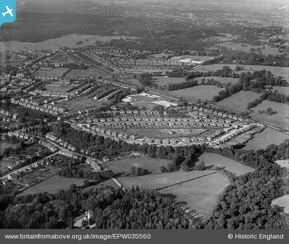
EPW035560 ENGLAND (1931). Housing surrounding Dale View Crescent and environs, Chingford, 1931
© Copyright OpenStreetMap contributors and licensed by the OpenStreetMap Foundation. 2026. Cartography is licensed as CC BY-SA.
Nearby Images (3)
EPW035560

EPW035558

EPW035561

Details
| Title | [EPW035560] Housing surrounding Dale View Crescent and environs, Chingford, 1931 |
| Reference | EPW035560 |
| Date | June-1931 |
| Link | |
| Place name | CHINGFORD |
| Parish | |
| District | |
| Country | ENGLAND |
| Easting / Northing | 538477, 193616 |
| Longitude / Latitude | 0.00069038749616963, 51.6238324712 |
| National Grid Reference | TQ385936 |
Pins

Peter R |
Monday 9th of November 2015 11:42:04 AM | |
|
Elmo |
Thursday 26th of September 2013 02:01:49 PM | |
|
Elmo |
Thursday 26th of September 2013 01:48:23 PM | |

Maurice |
Monday 28th of January 2013 08:17:58 AM | |
|
Maurice |
Monday 28th of January 2013 08:17:32 AM | |
|
Maurice |
Monday 28th of January 2013 08:11:42 AM | |
The developer apparently went bust and the land was sold off to residents who wanted it, hence on current day image some houses have extra land others don't. Original plan was to provide residents with tennis courts / recreation area. |
Richard |
Monday 15th of April 2013 09:22:30 AM |