
EPW035542 ENGLAND (1931). Housing surrounding The Chase, Burnt Oak and environs, Edgware, 1931

© Copyright OpenStreetMap contributors and licensed by the OpenStreetMap Foundation. 2026. Cartography is licensed as CC BY-SA.
Nearby Images (3)
EPW035542

EPW035545

EPW020062

Details
| Title | [EPW035542] Housing surrounding The Chase, Burnt Oak and environs, Edgware, 1931 |
| Reference | EPW035542 |
| Date | June-1931 |
| Link | |
| Place name | EDGWARE |
| Parish | |
| District | |
| Country | ENGLAND |
| Easting / Northing | 519580, 190773 |
| Longitude / Latitude | -0.27315605198278, 51.602612749432 |
| National Grid Reference | TQ196908 |
Pins

Danish A |
Friday 27th of May 2016 12:35:55 AM | |
|
Danish A |
Friday 27th of May 2016 12:35:21 AM | |
|
Danish A |
Friday 27th of May 2016 12:34:48 AM | |
|
Danish A |
Friday 27th of May 2016 12:32:03 AM | |
|
Danish A |
Friday 27th of May 2016 12:31:41 AM | |
|
Danish A |
Friday 27th of May 2016 12:30:50 AM | |
|
ken |
Tuesday 13th of October 2015 07:06:25 PM | |
|
The Laird |
Monday 27th of April 2015 05:38:43 PM | |
|
The Laird |
Monday 27th of April 2015 05:37:29 PM | |
|
The Laird |
Monday 27th of April 2015 05:06:21 PM | |
|
The Laird |
Monday 27th of April 2015 04:47:13 PM | |
|
The Laird |
Monday 27th of April 2015 04:45:31 PM | |
|
The Laird |
Monday 27th of April 2015 04:44:54 PM | |
|
colsouth111 |
Sunday 16th of December 2012 10:54:31 PM | |
|
colsouth111 |
Sunday 16th of December 2012 09:08:37 PM | |
|
colsouth111 |
Sunday 16th of December 2012 09:07:56 PM | |
|
colsouth111 |
Sunday 16th of December 2012 09:03:50 PM | |
|
colsouth111 |
Sunday 16th of December 2012 09:01:58 PM | |
|
colsouth111 |
Sunday 16th of December 2012 09:00:22 PM | |
|
colsouth111 |
Sunday 16th of December 2012 08:59:04 PM |
User Comment Contributions
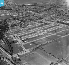
The Canada Park estate spreads out with geometric precision. |
colsouth111 |
Thursday 27th of June 2013 08:09:33 PM |
This image illustrates the rapid development of the district when compared to pictures from 1926/7. The Canada Park estate shown here is halfway to completion. Interesting to note that the building of Vancover Mansions predated Vancover road by some 9 years. |
colsouth111 |
Sunday 16th of December 2012 09:00:57 PM |