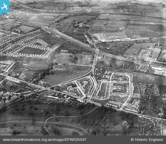
EPW035097 ENGLAND (1931). The Great West Road, Syon Lane and environs, Spring Grove, 1931
© Copyright OpenStreetMap contributors and licensed by the OpenStreetMap Foundation. 2026. Cartography is licensed as CC BY-SA.
Nearby Images (11)
Details
| Title | [EPW035097] The Great West Road, Syon Lane and environs, Spring Grove, 1931 |
| Reference | EPW035097 |
| Date | May-1931 |
| Link | |
| Place name | SPRING GROVE |
| Parish | |
| District | |
| Country | ENGLAND |
| Easting / Northing | 516387, 177142 |
| Longitude / Latitude | -0.32375305974294, 51.480758477634 |
| National Grid Reference | TQ164771 |
Pins

Sun |
Monday 24th of July 2023 10:15:28 PM | |

OldAdam |
Tuesday 9th of August 2022 07:22:43 PM | |

OldAdam |
Tuesday 9th of August 2022 07:21:35 PM | |

OldAdam |
Tuesday 9th of August 2022 07:19:47 PM | |

Mozzy |
Monday 31st of October 2016 05:46:25 PM | |

Mozzy |
Monday 31st of October 2016 05:45:18 PM | |

Mozzy |
Monday 31st of October 2016 05:44:29 PM | |

YvonneD |
Wednesday 10th of June 2015 12:49:10 AM | |

YvonneD |
Wednesday 10th of June 2015 12:48:05 AM | |

SimonRoberts |
Monday 29th of April 2013 09:17:55 PM | |
I'm sorry but this isn't Osterley House. It may be the builders yard which used to be Secombes. Osterley House is 1 mile north west of this building. |

Andy North |
Friday 30th of May 2014 05:08:45 PM |
This is neither Osterley House nor Seccombes, but it is Wyke House. demolished in the late 1970s, |

Isleworth1961 |
Saturday 7th of June 2014 12:53:40 AM |


![[EPW035097] The Great West Road, Syon Lane and environs, Spring Grove, 1931](http://britainfromabove.org.uk/sites/all/libraries/aerofilms-images/public/100x100/EPW/035/EPW035097.jpg)
![[EPW034929] Housing at Brentford End under construction and Syon Park, Brentford End, 1931](http://britainfromabove.org.uk/sites/all/libraries/aerofilms-images/public/100x100/EPW/034/EPW034929.jpg)
![[EPW050304] Housing alongside the Great West Road, the Gillette factory under construction and the Imperial Biscuit Works, Brentford End, 1936](http://britainfromabove.org.uk/sites/all/libraries/aerofilms-images/public/100x100/EPW/050/EPW050304.jpg)
![[EPR000527] Brittol House and the Coty Ltd Perfume Manufactory on the Great West Road, Spring Grove, 1935](http://britainfromabove.org.uk/sites/all/libraries/aerofilms-images/public/100x100/EPR/000/EPR000527.jpg)
![[EPR000525] Sir William Burnett & Co (Chemicals) Ltd Soldering Fluid Manufactory on the Great West Road, Spring Grove, 1935](http://britainfromabove.org.uk/sites/all/libraries/aerofilms-images/public/100x100/EPR/000/EPR000525.jpg)
![[EAW013193] Lincoln Cars Ltd, and the Coty Ltd Cosmetics Factory on the Great West Road and environs, Brentford End, 1948. This image has been produced from a print marked by Aerofilms Ltd for photo editing.](http://britainfromabove.org.uk/sites/all/libraries/aerofilms-images/public/100x100/EAW/013/EAW013193.jpg)
![[EAW013188] Lincoln Cars Ltd and the Coty Ltd Cosmetics Factory, Brentford End, 1948. This image has been produced from a print marked by Aerofilms Ltd for photo editing.](http://britainfromabove.org.uk/sites/all/libraries/aerofilms-images/public/100x100/EAW/013/EAW013188.jpg)
![[EAW013192] Lincoln Cars Ltd, and the Coty Ltd Cosmetics Factory on the Great West Road, Brentford End, 1948. This image has been produced from a print marked by Aerofilms Ltd for photo editing.](http://britainfromabove.org.uk/sites/all/libraries/aerofilms-images/public/100x100/EAW/013/EAW013192.jpg)
![[EPR000524] Sir William Burnett & Co (Chemicals) Ltd Soldering Fluid Manufactory on the Great West Road, Spring Grove, 1935](http://britainfromabove.org.uk/sites/all/libraries/aerofilms-images/public/100x100/EPR/000/EPR000524.jpg)
![[EAW013184] Lincoln Cars Ltd and the Coty Ltd Cosmetics Factory on the Great West Road, Brentford End, 1948. This image has been produced from a print marked by Aerofilms Ltd for photo editing.](http://britainfromabove.org.uk/sites/all/libraries/aerofilms-images/public/100x100/EAW/013/EAW013184.jpg)
![[EAW013185] Lincoln Cars Ltd, the Coty Ltd Cosmetics Factory on the Great West Road and environs, Brentford End, 1948. This image has been produced from a print.](http://britainfromabove.org.uk/sites/all/libraries/aerofilms-images/public/100x100/EAW/013/EAW013185.jpg)