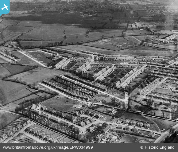
EPW034999 ENGLAND (1931). Residential development around Glenalmond Road and D'Arcy Gardens, Kenton, 1931
    © Copyright OpenStreetMap contributors and licensed by the OpenStreetMap Foundation. 2025. Cartography is licensed as CC BY-SA.
  
Details
| Title | [EPW034999] Residential development around Glenalmond Road and D'Arcy Gardens, Kenton, 1931 | 
| Reference | EPW034999 | 
| Date | May-1931 | 
| Link | |
| Place name | KENTON | 
| Parish | |
| District | |
| Country | ENGLAND | 
| Easting / Northing | 518185, 189351 | 
| Longitude / Latitude | -0.29377057565123, 51.590125826572 | 
| National Grid Reference | TQ182894 | 
Pins
|  Glebe Avenue yet to be built on |   mike | Monday 22nd of November 2021 04:00:57 PM | 
|  Site of future Glebe Infant School |   mike | Monday 22nd of November 2021 04:00:05 PM | 
|  Charlton Road |   trueglory | Friday 29th of November 2019 11:52:07 PM | 
|  De Havilland Aircraft factory at Stag Lane Aerodrome. Within the a few short years, the company would move its main plant to a larger site in Hatfield and the aerodrome would disappear under housing. |   The Laird | Thursday 29th of March 2018 03:39:35 PM | 
|  Preparatory route of the Stanmore branch of the Metropolitan Railway and approximate site of forthcoming Queensbury Station. |   The Laird | Thursday 29th of March 2018 03:28:44 PM | 
|  Stanmore Isolation Hospital.  A small local isolation hospital opened in 1905 and closed in 1948 upon the introduction of the the NHS. The local authority utilised the buildings as a residential nursery. The site has now been completely redeveloped. |   The Laird | Thursday 29th of March 2018 03:04:23 PM | 
|  Honeypot Lane |   csunderland | Wednesday 16th of September 2015 10:48:39 AM | 
|  Kenton Road (and small part of the North edge of Kenton Grange land, to the South) |   csunderland | Wednesday 16th of September 2015 10:47:55 AM | 
|  Westfield Gardens |   csunderland | Wednesday 16th of September 2015 10:46:25 AM | 
|  Westfield Drive |   csunderland | Wednesday 16th of September 2015 10:45:46 AM | 
 
             
  ![[EPW034999] Residential development around Glenalmond Road and D'Arcy Gardens, Kenton,  1931](http://britainfromabove.org.uk/sites/all/libraries/aerofilms-images/public/100x100/EPW/034/EPW034999.jpg) 
  
                                          ![[EAW044761] The residential area at Queensbury and Belmont, Queensbury, 1952](http://britainfromabove.org.uk/sites/all/libraries/aerofilms-images/public/100x100/EAW/044/EAW044761.jpg) 
 ![[EPW035000] Residential area around Camplin Road and Kenton Road, Kenton,  1931](http://britainfromabove.org.uk/sites/all/libraries/aerofilms-images/public/100x100/EPW/035/EPW035000.jpg)