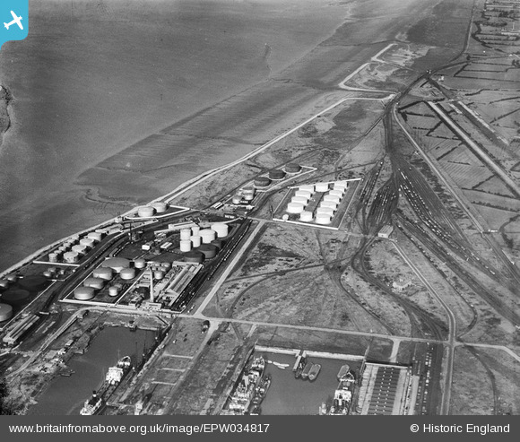
EPW034817 ENGLAND (1931). Fuel storage depot, Avonmouth, 1931
© Copyright OpenStreetMap contributors and licensed by the OpenStreetMap Foundation. 2025. Cartography is licensed as CC BY-SA.
Nearby Images (12)
Details
| Title | [EPW034817] Fuel storage depot, Avonmouth, 1931 |
| Reference | EPW034817 |
| Date | 17-February-1931 |
| Link | |
| Place name | AVONMOUTH |
| Parish | |
| District | |
| Country | ENGLAND |
| Easting / Northing | 351542, 179845 |
| Longitude / Latitude | -2.6984135927765, 51.51496618299 |
| National Grid Reference | ST515798 |
Pins

MB |
Saturday 20th of August 2016 04:29:18 PM | |

MB |
Saturday 20th of August 2016 04:25:29 PM | |

MB |
Saturday 20th of August 2016 04:24:57 PM | |

MB |
Saturday 20th of August 2016 04:24:14 PM |


![[EPW034817] Fuel storage depot, Avonmouth, 1931](http://britainfromabove.org.uk/sites/all/libraries/aerofilms-images/public/100x100/EPW/034/EPW034817.jpg)
![[EPW034822] Fuel storage depot, Avonmouth, 1931](http://britainfromabove.org.uk/sites/all/libraries/aerofilms-images/public/100x100/EPW/034/EPW034822.jpg)
![[EPW034823] Fuel storage depot, Avonmouth, 1931](http://britainfromabove.org.uk/sites/all/libraries/aerofilms-images/public/100x100/EPW/034/EPW034823.jpg)
![[EPW034821] Fuel storage depot, Avonmouth, 1931](http://britainfromabove.org.uk/sites/all/libraries/aerofilms-images/public/100x100/EPW/034/EPW034821.jpg)
![[EPW034826] Fuel storage depot, Avonmouth, 1931](http://britainfromabove.org.uk/sites/all/libraries/aerofilms-images/public/100x100/EPW/034/EPW034826.jpg)
![[EPW034825] Fuel storage depot, Avonmouth, 1931](http://britainfromabove.org.uk/sites/all/libraries/aerofilms-images/public/100x100/EPW/034/EPW034825.jpg)
![[EPW034827] Fuel storage depot, Avonmouth, 1931](http://britainfromabove.org.uk/sites/all/libraries/aerofilms-images/public/100x100/EPW/034/EPW034827.jpg)
![[EPW034818] Fuel storage depot, Avonmouth, 1931](http://britainfromabove.org.uk/sites/all/libraries/aerofilms-images/public/100x100/EPW/034/EPW034818.jpg)
![[EPW034824] Fuel storage depot, Avonmouth, 1931](http://britainfromabove.org.uk/sites/all/libraries/aerofilms-images/public/100x100/EPW/034/EPW034824.jpg)
![[EPW034820] Fuel storage depot, Avonmouth, 1931](http://britainfromabove.org.uk/sites/all/libraries/aerofilms-images/public/100x100/EPW/034/EPW034820.jpg)
![[EPW034819] Fuel storage depot, Avonmouth, 1931](http://britainfromabove.org.uk/sites/all/libraries/aerofilms-images/public/100x100/EPW/034/EPW034819.jpg)
![[EAW039919] The site of the Regent Oil Co Storage Depot fire, Avonmouth, 1951. This image has been produced from a damaged negative.](http://britainfromabove.org.uk/sites/all/libraries/aerofilms-images/public/100x100/EAW/039/EAW039919.jpg)