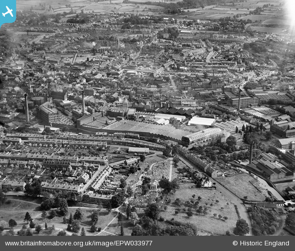
EPW033977 ENGLAND (1930). The town centre, Kidderminster, from the south-west, 1930
© Copyright OpenStreetMap contributors and licensed by the OpenStreetMap Foundation. 2026. Cartography is licensed as CC BY-SA.
Nearby Images (22)
Details
| Title | [EPW033977] The town centre, Kidderminster, from the south-west, 1930 |
| Reference | EPW033977 |
| Date | July-1930 |
| Link | |
| Place name | KIDDERMINSTER |
| Parish | |
| District | |
| Country | ENGLAND |
| Easting / Northing | 382874, 276222 |
| Longitude / Latitude | -2.2516459227319, 52.383381635611 |
| National Grid Reference | SO829762 |
Pins
Be the first to add a comment to this image!


![[EPW033977] The town centre, Kidderminster, from the south-west, 1930](http://britainfromabove.org.uk/sites/all/libraries/aerofilms-images/public/100x100/EPW/033/EPW033977.jpg)
![[EPW033969] The town centre, Kidderminster, from the south-west, 1930](http://britainfromabove.org.uk/sites/all/libraries/aerofilms-images/public/100x100/EPW/033/EPW033969.jpg)
![[EPW034227] The Carpet Works and environs, Kidderminster, from the south-west, 1930](http://britainfromabove.org.uk/sites/all/libraries/aerofilms-images/public/100x100/EPW/034/EPW034227.jpg)
![[EPW033979] The town centre, Kidderminster, from the south, 1930](http://britainfromabove.org.uk/sites/all/libraries/aerofilms-images/public/100x100/EPW/033/EPW033979.jpg)
![[EPW034232] The town and surrounding countryside, Kidderminster, from the south-west, 1930](http://britainfromabove.org.uk/sites/all/libraries/aerofilms-images/public/100x100/EPW/034/EPW034232.jpg)
![[EPW033972] The town centre, Kidderminster, from the south, 1930](http://britainfromabove.org.uk/sites/all/libraries/aerofilms-images/public/100x100/EPW/033/EPW033972.jpg)
![[EPW033970] Carpet Works and factories in the town centre, Kidderminster, 1930](http://britainfromabove.org.uk/sites/all/libraries/aerofilms-images/public/100x100/EPW/033/EPW033970.jpg)
![[EPW033973] Carpet Works and factories in the town centre, Kidderminster, 1930](http://britainfromabove.org.uk/sites/all/libraries/aerofilms-images/public/100x100/EPW/033/EPW033973.jpg)
![[EPW033974] The town centre, Kidderminster, from the south, 1930](http://britainfromabove.org.uk/sites/all/libraries/aerofilms-images/public/100x100/EPW/033/EPW033974.jpg)
![[EPW033975] Carpet Works and factories in the town centre, Kidderminster, 1930](http://britainfromabove.org.uk/sites/all/libraries/aerofilms-images/public/100x100/EPW/033/EPW033975.jpg)
![[EPW033976] Carpet Works and factories in the town centre, Kidderminster, 1930](http://britainfromabove.org.uk/sites/all/libraries/aerofilms-images/public/100x100/EPW/033/EPW033976.jpg)
![[EPW033971] Carpet Works and factories in the town centre, Kidderminster, 1930](http://britainfromabove.org.uk/sites/all/libraries/aerofilms-images/public/100x100/EPW/033/EPW033971.jpg)
![[EPW001297] Carpet works and Slingfield Spinning Mill, Kidderminster, 1920](http://britainfromabove.org.uk/sites/all/libraries/aerofilms-images/public/100x100/EPW/001/EPW001297.jpg)
![[EPW033968] Carpet Works and factories in the town centre, Kidderminster, 1930](http://britainfromabove.org.uk/sites/all/libraries/aerofilms-images/public/100x100/EPW/033/EPW033968.jpg)
![[EPW059212] Brintons Ltd Carpet Factory and environs, Kidderminster, 1938](http://britainfromabove.org.uk/sites/all/libraries/aerofilms-images/public/100x100/EPW/059/EPW059212.jpg)
![[EPW037611] Mills and Carpet Works on New Road and Green Street, Kidderminster, from the south-west, 1932](http://britainfromabove.org.uk/sites/all/libraries/aerofilms-images/public/100x100/EPW/037/EPW037611.jpg)
![[EPW037599] The town centre, Kidderminster, from the south-west, 1932](http://britainfromabove.org.uk/sites/all/libraries/aerofilms-images/public/100x100/EPW/037/EPW037599.jpg)
![[EPW059213] Brintons Ltd Carpet Factory, New Road and environs, Kidderminster, 1938](http://britainfromabove.org.uk/sites/all/libraries/aerofilms-images/public/100x100/EPW/059/EPW059213.jpg)
![[EPW059215] Brintons Ltd Carpet Factory, New Road and environs, Kidderminster, 1938](http://britainfromabove.org.uk/sites/all/libraries/aerofilms-images/public/100x100/EPW/059/EPW059215.jpg)
![[EPW059217] Brintons Ltd Carpet Factory and environs, Kidderminster, 1938](http://britainfromabove.org.uk/sites/all/libraries/aerofilms-images/public/100x100/EPW/059/EPW059217.jpg)
![[EPW059211] Brintons Ltd Carpet Factory, New Road and environs, Kidderminster, 1938](http://britainfromabove.org.uk/sites/all/libraries/aerofilms-images/public/100x100/EPW/059/EPW059211.jpg)
![[EPW059214] Brintons Ltd Carpet Factory, New Road and environs, Kidderminster, 1938](http://britainfromabove.org.uk/sites/all/libraries/aerofilms-images/public/100x100/EPW/059/EPW059214.jpg)