
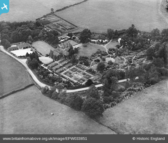
EPW033851 ENGLAND (1930). Homestall, Stoke Brunswick, 1930
© Copyright OpenStreetMap contributors and licensed by the OpenStreetMap Foundation. 2026. Cartography is licensed as CC BY-SA.
Nearby Images (18)
EPW033851

EPW033848

EPW033852

EPW033853

EPW057652
, Forest Row, 1938. This image has been produced from a damaged negative.")
EPW057653
, Forest Row, 1938. This image has been produced from a damaged negative.")
EPW033847

EPW058218
, Forest Row, 1938")
EPW033849

EPW057654
, Forest Row, 1938. This image has been produced from a damaged negative.")
EPW033850

EPW058220
, Forest Row, 1938")
EPW058216
, Forest Row, 1938")
EPW058219
, Forest Row, from the west, 1938")
EPW058217
, Forest Row, from the west, 1938")
EPW058215
, Forest Row, 1938")
EPW057651
 and the surrounding countryside, Forest Row, from the north-west, 1938. This image has been produced from a damaged negative.")
EPW058221
 and surrounding countryside, Forest Row, from the south-west, 1938")
Details
| Title | [EPW033851] Homestall, Stoke Brunswick, 1930 |
| Reference | EPW033851 |
| Date | July-1930 |
| Link | |
| Place name | STOKE BRUNSWICK |
| Parish | FOREST ROW |
| District | |
| Country | ENGLAND |
| Easting / Northing | 542187, 137432 |
| Longitude / Latitude | 0.031774558985608, 51.117982451876 |
| National Grid Reference | TQ422374 |
Pins
Be the first to add a comment to this image!
User Comment Contributions
For 1938 images see eg image EPW058215 which is confusingly under the name FOREST ROW unlike these 1930 images which are under STOKE BRUNSWICK! |

totoro |
Tuesday 30th of July 2013 09:06:32 PM |