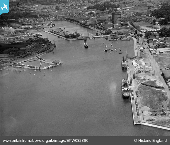
EPW032860 ENGLAND (1930). The docks, Ipswich, 1930
© Copyright OpenStreetMap contributors and licensed by the OpenStreetMap Foundation. 2026. Cartography is licensed as CC BY-SA.
Nearby Images (11)
Details
| Title | [EPW032860] The docks, Ipswich, 1930 |
| Reference | EPW032860 |
| Date | June-1930 |
| Link | |
| Place name | IPSWICH |
| Parish | |
| District | |
| Country | ENGLAND |
| Easting / Northing | 616848, 243027 |
| Longitude / Latitude | 1.1624276097287, 52.042734054157 |
| National Grid Reference | TM168430 |
Pins
Be the first to add a comment to this image!


![[EPW032860] The docks, Ipswich, 1930](http://britainfromabove.org.uk/sites/all/libraries/aerofilms-images/public/100x100/EPW/032/EPW032860.jpg)
![[EPW032841] The docks, Ipswich, 1930](http://britainfromabove.org.uk/sites/all/libraries/aerofilms-images/public/100x100/EPW/032/EPW032841.jpg)
![[EPW032857] The docks and environs, Ipswich, 1930](http://britainfromabove.org.uk/sites/all/libraries/aerofilms-images/public/100x100/EPW/032/EPW032857.jpg)
![[EPW032851] The Bathing Place, Ipswich, 1930](http://britainfromabove.org.uk/sites/all/libraries/aerofilms-images/public/100x100/EPW/032/EPW032851.jpg)
![[EAW025121] Gabriel, Wade and English Timber Yard and the River Orwell looking along Wet Dock, Ipswich, 1949. This image was marked by Aerofilms Ltd for photo editing.](http://britainfromabove.org.uk/sites/all/libraries/aerofilms-images/public/100x100/EAW/025/EAW025121.jpg)
![[EAW025117] Gabriel, Wade and English Timber Yard, Greenwich Road and environs, Ipswich, from the west, 1949](http://britainfromabove.org.uk/sites/all/libraries/aerofilms-images/public/100x100/EAW/025/EAW025117.jpg)
![[EPW032850] Holywells Park and the docks, Ipswich, 1930](http://britainfromabove.org.uk/sites/all/libraries/aerofilms-images/public/100x100/EPW/032/EPW032850.jpg)
![[EAW025123] Gabriel, Wade and English Timber Yard and environs, Ipswich, 1949](http://britainfromabove.org.uk/sites/all/libraries/aerofilms-images/public/100x100/EAW/025/EAW025123.jpg)
![[EPW041401] The docks, Ipswich, from the south-west, 1933](http://britainfromabove.org.uk/sites/all/libraries/aerofilms-images/public/100x100/EPW/041/EPW041401.jpg)
![[EAW025122] Gabriel, Wade and English Timber Yard and environs, Ipswich, from the north, 1949](http://britainfromabove.org.uk/sites/all/libraries/aerofilms-images/public/100x100/EAW/025/EAW025122.jpg)
![[EPW032847] The docks and town, Ipswich, from the south-east, 1930](http://britainfromabove.org.uk/sites/all/libraries/aerofilms-images/public/100x100/EPW/032/EPW032847.jpg)