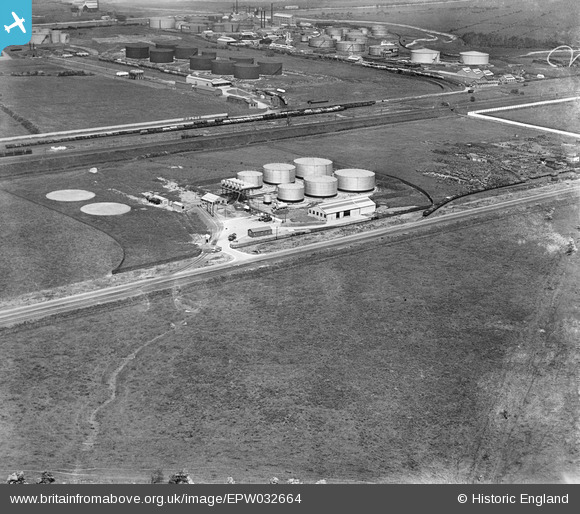
EPW032664 ENGLAND (1930). An oil depot on the south side of the Hooton and Helsby Branch Railway, Stanlow, 1930
© Copyright OpenStreetMap contributors and licensed by the OpenStreetMap Foundation. 2026. Cartography is licensed as CC BY-SA.
Nearby Images (17)
Details
| Title | [EPW032664] An oil depot on the south side of the Hooton and Helsby Branch Railway, Stanlow, 1930 |
| Reference | EPW032664 |
| Date | June-1930 |
| Link | |
| Place name | STANLOW |
| Parish | |
| District | |
| Country | ENGLAND |
| Easting / Northing | 342104, 376054 |
| Longitude / Latitude | -2.8683793100714, 53.278024772318 |
| National Grid Reference | SJ421761 |
Pins

Bottom Yard |
Sunday 6th of January 2019 06:29:13 PM | |

Bottom Yard |
Sunday 6th of January 2019 05:07:59 PM | |

Bottom Yard |
Sunday 6th of January 2019 05:06:00 PM | |

Bottom Yard |
Sunday 6th of January 2019 05:04:51 PM | |

Bottom Yard |
Sunday 6th of January 2019 05:03:22 PM | |

Bottom Yard |
Sunday 6th of January 2019 04:57:31 PM | |

Bottom Yard |
Sunday 6th of January 2019 04:55:57 PM | |

Bottom Yard |
Sunday 6th of January 2019 04:55:12 PM | |

Bottom Yard |
Sunday 6th of January 2019 04:52:11 PM | |

Bottom Yard |
Sunday 6th of January 2019 04:50:49 PM | |

Bottom Yard |
Sunday 6th of January 2019 04:49:38 PM | |

Bottom Yard |
Sunday 6th of January 2019 04:48:24 PM |


![[EPW032664] An oil depot on the south side of the Hooton and Helsby Branch Railway, Stanlow, 1930](http://britainfromabove.org.uk/sites/all/libraries/aerofilms-images/public/100x100/EPW/032/EPW032664.jpg)
![[EPW032668] An oil depot on the south side of the Hooton and Helsby Branch Railway, Stanlow, 1930](http://britainfromabove.org.uk/sites/all/libraries/aerofilms-images/public/100x100/EPW/032/EPW032668.jpg)
![[EPW032662] An oil depot on the south side of the Hooton and Helsby Branch Railway, Stanlow, 1930](http://britainfromabove.org.uk/sites/all/libraries/aerofilms-images/public/100x100/EPW/032/EPW032662.jpg)
![[EPW032663] An oil depot on the south side of the Hooton and Helsby Branch Railway, Stanlow, 1930](http://britainfromabove.org.uk/sites/all/libraries/aerofilms-images/public/100x100/EPW/032/EPW032663.jpg)
![[EPW032665] An oil depot on the south side of the Hooton and Helsby Branch Railway, Stanlow, 1930](http://britainfromabove.org.uk/sites/all/libraries/aerofilms-images/public/100x100/EPW/032/EPW032665.jpg)
![[EPW032667] An oil depot on the south side of the Hooton and Helsby Branch Railway, Stanlow, 1930](http://britainfromabove.org.uk/sites/all/libraries/aerofilms-images/public/100x100/EPW/032/EPW032667.jpg)
![[EPW032666] An oil depot on the south side of the Hooton and Helsby Branch Railway, Stanlow, 1930](http://britainfromabove.org.uk/sites/all/libraries/aerofilms-images/public/100x100/EPW/032/EPW032666.jpg)
![[EPW032669] An oil depot on the south side of the Hooton and Helsby Branch Railway, Stanlow, 1930](http://britainfromabove.org.uk/sites/all/libraries/aerofilms-images/public/100x100/EPW/032/EPW032669.jpg)
![[EPW037729] The Cleveland Motor Spirit Depot, Stanlow, 1932](http://britainfromabove.org.uk/sites/all/libraries/aerofilms-images/public/100x100/EPW/037/EPW037729.jpg)
![[EAW038946] The James Crosby & Sons Ltd Works off Bridges Road, Ellesmere Port, from the north-west, 1951. This image has been produced from a damaged negative.](http://britainfromabove.org.uk/sites/all/libraries/aerofilms-images/public/100x100/EAW/038/EAW038946.jpg)
![[EAW038949] The James Crosby & Sons Ltd Works off Bridges Road, Ellesmere Port, 1951. This image has been produced from a damaged negative.](http://britainfromabove.org.uk/sites/all/libraries/aerofilms-images/public/100x100/EAW/038/EAW038949.jpg)
![[EAW038951] The James Crosby & Sons Ltd Works off Bridges Road, Ellesmere Port, 1951. This image was marked by Aerofilms Ltd for photo editing.](http://britainfromabove.org.uk/sites/all/libraries/aerofilms-images/public/100x100/EAW/038/EAW038951.jpg)
![[EAW038944] The James Crosby & Sons Ltd Works off Bridges Road, Ellesmere Port, 1951. This image has been produced from a damaged negative.](http://britainfromabove.org.uk/sites/all/libraries/aerofilms-images/public/100x100/EAW/038/EAW038944.jpg)
![[EAW038948] The James Crosby & Sons Ltd Works off Bridges Road, Ellesmere Port, 1951. This image has been produced from a damaged negative.](http://britainfromabove.org.uk/sites/all/libraries/aerofilms-images/public/100x100/EAW/038/EAW038948.jpg)
![[EAW038945] The James Crosby & Sons Ltd Works off Bridges Road, Ellesmere Port, 1951. This image has been produced from a damaged negative.](http://britainfromabove.org.uk/sites/all/libraries/aerofilms-images/public/100x100/EAW/038/EAW038945.jpg)
![[EAW038947] The James Crosby & Sons Ltd Works off Bridges Road, Ellesmere Port, 1951. This image has been produced from a damaged negative.](http://britainfromabove.org.uk/sites/all/libraries/aerofilms-images/public/100x100/EAW/038/EAW038947.jpg)
![[EAW038953] The James Crosby & Sons Ltd Works off Bridges Road, Ellesmere Port, 1951. This image has been produced from a print marked by Aerofilms Ltd for photo editing.](http://britainfromabove.org.uk/sites/all/libraries/aerofilms-images/public/100x100/EAW/038/EAW038953.jpg)