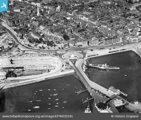
EPW032341 ENGLAND (1930). The Royal Pier and a paddle steamer in the Town Quay, Southampton, 1930
© Copyright OpenStreetMap contributors and licensed by the OpenStreetMap Foundation. 2026. Cartography is licensed as CC BY-SA.
Nearby Images (8)
Details
| Title | [EPW032341] The Royal Pier and a paddle steamer in the Town Quay, Southampton, 1930 |
| Reference | EPW032341 |
| Date | June-1930 |
| Link | |
| Place name | SOUTHAMPTON |
| Parish | |
| District | |
| Country | ENGLAND |
| Easting / Northing | 441802, 111009 |
| Longitude / Latitude | -1.4055343165692, 50.896492504153 |
| National Grid Reference | SU418110 |
Pins

Liz coe |
Friday 28th of February 2020 12:39:38 PM | |

alastair wallace |
Thursday 29th of October 2015 09:01:32 PM | |

mannidaze |
Sunday 16th of November 2014 09:06:23 PM | |

Class31 |
Friday 30th of May 2014 08:42:16 PM | |

Class31 |
Friday 30th of May 2014 08:39:56 PM | |

Class31 |
Friday 30th of May 2014 08:37:03 PM | |

Class31 |
Friday 2nd of May 2014 04:17:53 PM | |

Maurice |
Saturday 19th of January 2013 08:22:50 AM |
User Comment Contributions
Mary Anne Rogers Memorial, Southampton 29/05/2014 |

Class31 |
Friday 30th of May 2014 08:41:20 PM |


![[EPW032341] The Royal Pier and a paddle steamer in the Town Quay, Southampton, 1930](http://britainfromabove.org.uk/sites/all/libraries/aerofilms-images/public/100x100/EPW/032/EPW032341.jpg)
![[EPW020447] Town Quay, Southampton, 1928](http://britainfromabove.org.uk/sites/all/libraries/aerofilms-images/public/100x100/EPW/020/EPW020447.jpg)
![[EPW009072] The Town Quay and Royal Pier, Southampton, 1923](http://britainfromabove.org.uk/sites/all/libraries/aerofilms-images/public/100x100/EPW/009/EPW009072.jpg)
![[EPW042962] High Street and environs, Southampton, from the south, 1933](http://britainfromabove.org.uk/sites/all/libraries/aerofilms-images/public/100x100/EPW/042/EPW042962.jpg)
![[EAW022289] The Royal Pier, Southampton, 1949](http://britainfromabove.org.uk/sites/all/libraries/aerofilms-images/public/100x100/EAW/022/EAW022289.jpg)
![[EAR030076] Royal Pier, Southamton, 1957](http://britainfromabove.org.uk/sites/all/libraries/aerofilms-images/public/100x100/EAR/030/EAR030076.jpg)
![[EPW041065] Ocean Dock, the RMS Mauretania in the floating dry dock and environs, Southampton, from the north-west, 1933](http://britainfromabove.org.uk/sites/all/libraries/aerofilms-images/public/100x100/EPW/041/EPW041065.jpg)
![[EPW041063] Reclamation of the Western Docks between Royal Pier and Millbrook, Southampton, from the south-east, 1933](http://britainfromabove.org.uk/sites/all/libraries/aerofilms-images/public/100x100/EPW/041/EPW041063.jpg)