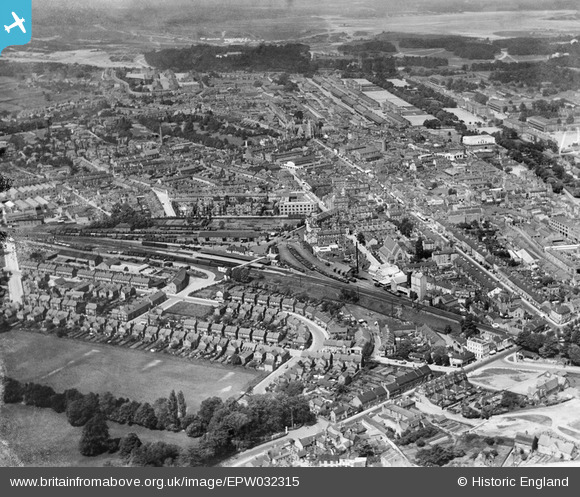
EPW032315 ENGLAND (1930). The town, railway station and goods yard, Aldershot, from the south-east, 1930
© Copyright OpenStreetMap contributors and licensed by the OpenStreetMap Foundation. 2026. Cartography is licensed as CC BY-SA.
Details
| Title | [EPW032315] The town, railway station and goods yard, Aldershot, from the south-east, 1930 |
| Reference | EPW032315 |
| Date | 5-June-1930 |
| Link | |
| Place name | ALDERSHOT |
| Parish | |
| District | |
| Country | ENGLAND |
| Easting / Northing | 486853, 150401 |
| Longitude / Latitude | -0.75551915580134, 51.245649187245 |
| National Grid Reference | SU869504 |
Pins

Charlotte Colmans |
Thursday 25th of April 2024 08:43:50 PM | |

Simon Chappell |
Friday 14th of October 2016 12:38:42 PM | |

Simon Chappell |
Friday 14th of October 2016 11:13:13 AM | |

David960 |
Sunday 1st of February 2015 05:44:27 PM | |

David960 |
Sunday 1st of February 2015 05:42:46 PM | |

David960 |
Sunday 1st of February 2015 05:41:04 PM | |

Sweet Pete |
Sunday 1st of February 2015 03:31:43 PM | |

The Laird |
Sunday 29th of June 2014 06:59:40 PM | |

The Laird |
Sunday 29th of June 2014 06:58:52 PM | |

The Laird |
Sunday 29th of June 2014 06:57:47 PM | |

The Laird |
Sunday 29th of June 2014 06:56:14 PM | |

The Laird |
Sunday 29th of June 2014 06:54:35 PM | |

The Laird |
Sunday 29th of June 2014 06:45:38 PM | |

flubber |
Monday 8th of July 2013 05:46:34 PM | |

flubber |
Monday 8th of July 2013 05:39:49 PM | |

flubber |
Monday 8th of July 2013 05:36:52 PM | |

Chris Willis |
Sunday 9th of June 2013 05:46:07 PM | |

Chris Willis |
Sunday 9th of June 2013 05:45:08 PM | |

Chris Willis |
Sunday 9th of June 2013 05:44:01 PM | |
Yes. Confirm this was the Gale & Polden printing works. |

flubber |
Monday 8th of July 2013 05:42:40 PM |

Chris Willis |
Sunday 9th of June 2013 05:23:22 PM | |

Chris Willis |
Sunday 9th of June 2013 05:21:35 PM | |

Chris Willis |
Sunday 9th of June 2013 05:21:09 PM | |

Chris Willis |
Sunday 9th of June 2013 05:19:58 PM | |

Chris Willis |
Sunday 9th of June 2013 05:19:32 PM | |

Chris Willis |
Sunday 9th of June 2013 05:17:41 PM | |

Chris Willis |
Sunday 9th of June 2013 05:16:54 PM | |

Chris Willis |
Sunday 9th of June 2013 05:15:34 PM | |

Chris Willis |
Sunday 9th of June 2013 05:14:55 PM |


![[EPW032315] The town, railway station and goods yard, Aldershot, from the south-east, 1930](http://britainfromabove.org.uk/sites/all/libraries/aerofilms-images/public/100x100/EPW/032/EPW032315.jpg)
![[EPW011003] Victoria Road and environs, Aldershot, from the south-east, 1924. This image has been produced from a print.](http://britainfromabove.org.uk/sites/all/libraries/aerofilms-images/public/100x100/EPW/011/EPW011003.jpg)