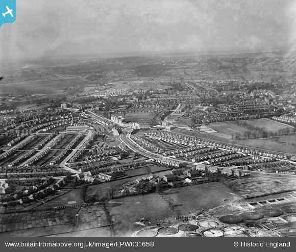
EPW031658 ENGLAND (1930). Central Circus, Hendon, from the south, 1930
© Copyright OpenStreetMap contributors and licensed by the OpenStreetMap Foundation. 2026. Cartography is licensed as CC BY-SA.
Nearby Images (48)
Details
| Title | [EPW031658] Central Circus, Hendon, from the south, 1930 |
| Reference | EPW031658 |
| Date | April-1930 |
| Link | |
| Place name | HENDON |
| Parish | |
| District | |
| Country | ENGLAND |
| Easting / Northing | 523088, 188164 |
| Longitude / Latitude | -0.22343842791666, 51.578407033263 |
| National Grid Reference | TQ231882 |
Pins
Be the first to add a comment to this image!


![[EPW031658] Central Circus, Hendon, from the south, 1930](http://britainfromabove.org.uk/sites/all/libraries/aerofilms-images/public/100x100/EPW/031/EPW031658.jpg)
![[EPW050374] The Johnson and Sons Photographic Chemical Factory, Park Road and environs, Hendon, 1936](http://britainfromabove.org.uk/sites/all/libraries/aerofilms-images/public/100x100/EPW/050/EPW050374.jpg)
![[EPW050375] Hendon Way, the Johnson and Sons Photographic Chemical Factory, Park Road and environs, Hendon, 1936](http://britainfromabove.org.uk/sites/all/libraries/aerofilms-images/public/100x100/EPW/050/EPW050375.jpg)
![[EPW050376] Hendon Way, the Johnson and Sons Photographic Chemical Factory, Park Road and environs, Hendon, 1936. This image was marked by Aerofilms Ltd for photo editing.](http://britainfromabove.org.uk/sites/all/libraries/aerofilms-images/public/100x100/EPW/050/EPW050376.jpg)
![[EPW050378] Hendon Way, the Johnson and Sons Photographic Chemical Factory, Park Road and environs, Hendon, 1936](http://britainfromabove.org.uk/sites/all/libraries/aerofilms-images/public/100x100/EPW/050/EPW050378.jpg)
![[EPW050377] Hendon Way, the Johnson and Sons Photographic Chemical Factory, Park Road and environs, Hendon, 1936](http://britainfromabove.org.uk/sites/all/libraries/aerofilms-images/public/100x100/EPW/050/EPW050377.jpg)
![[EPW022831] Johnson and Sons Manufactury Chemists Ltd Chemical Factory and the Hendon Corporation Sewage Farm, Hendon, 1928](http://britainfromabove.org.uk/sites/all/libraries/aerofilms-images/public/100x100/EPW/022/EPW022831.jpg)
![[EPW048977] The Johnson and Sons Photographic Chemical Factory, Hendon, 1935](http://britainfromabove.org.uk/sites/all/libraries/aerofilms-images/public/100x100/EPW/048/EPW048977.jpg)
![[EPW048978] The Johnson and Sons Photographic Chemical Factory, Hendon, 1935](http://britainfromabove.org.uk/sites/all/libraries/aerofilms-images/public/100x100/EPW/048/EPW048978.jpg)
![[EPW049219] Johnson and Sons Manufactury Chemists Ltd Chemical Factory and houses on Hendon Way, Hendon, 1935](http://britainfromabove.org.uk/sites/all/libraries/aerofilms-images/public/100x100/EPW/049/EPW049219.jpg)
![[EPW048980] The Johnson and Sons Photographic Chemical Factory, Hendon, 1935](http://britainfromabove.org.uk/sites/all/libraries/aerofilms-images/public/100x100/EPW/048/EPW048980.jpg)
![[EPW049220] Johnson and Sons Manufactury Chemists Ltd Chemical Factory and houses on Hendon Way, Hendon, 1935. This image has been affected by flare.](http://britainfromabove.org.uk/sites/all/libraries/aerofilms-images/public/100x100/EPW/049/EPW049220.jpg)
![[EPW050373] The Johnson and Sons Photographic Chemical Factory, Hendon, 1936. This image was marked by Aerofilms Ltd for photo editing.](http://britainfromabove.org.uk/sites/all/libraries/aerofilms-images/public/100x100/EPW/050/EPW050373.jpg)
![[EPW022370] Johnsons of Hendon Chemical Factory and the Hendon Corporation Sewage Farm, Hendon, 1928](http://britainfromabove.org.uk/sites/all/libraries/aerofilms-images/public/100x100/EPW/022/EPW022370.jpg)
![[EPW049485] The Johnson and Sons Ltd Chemical Factory, Hendon, 1935](http://britainfromabove.org.uk/sites/all/libraries/aerofilms-images/public/100x100/EPW/049/EPW049485.jpg)
![[EPW022830] Johnson and Sons Manufactury Chemists Ltd Chemical Factory and the Hendon Corporation Sewage Farm, Hendon, 1928](http://britainfromabove.org.uk/sites/all/libraries/aerofilms-images/public/100x100/EPW/022/EPW022830.jpg)
![[EPW022371] Johnsons of Hendon Chemical Factory and the Hendon Corporation Sewage Farm, Hendon, 1928](http://britainfromabove.org.uk/sites/all/libraries/aerofilms-images/public/100x100/EPW/022/EPW022371.jpg)
![[EPW022373] Johnsons of Hendon Chemical Factory and the Hendon Corporation Sewage Farm, Hendon, 1928](http://britainfromabove.org.uk/sites/all/libraries/aerofilms-images/public/100x100/EPW/022/EPW022373.jpg)
![[EPW010014] Hendon Cottage Hospital, Hendon, 1924. This image has been produced from a print.](http://britainfromabove.org.uk/sites/all/libraries/aerofilms-images/public/100x100/EPW/010/EPW010014.jpg)
![[EPW048981] The Johnson and Sons Photographic Chemical Factory, Hendon, 1935](http://britainfromabove.org.uk/sites/all/libraries/aerofilms-images/public/100x100/EPW/048/EPW048981.jpg)
![[EPW049483] The Johnson and Sons Ltd Chemical Factory, Hendon, 1935](http://britainfromabove.org.uk/sites/all/libraries/aerofilms-images/public/100x100/EPW/049/EPW049483.jpg)
![[EPW049487] The Johnson and Sons Ltd Chemical Factory, Hendon, 1935](http://britainfromabove.org.uk/sites/all/libraries/aerofilms-images/public/100x100/EPW/049/EPW049487.jpg)
![[EAW023660] The Johnson and Sons Chemical Factory, Hendon, 1949](http://britainfromabove.org.uk/sites/all/libraries/aerofilms-images/public/100x100/EAW/023/EAW023660.jpg)
![[EPW048979] The Johnson and Sons Photographic Chemical Factory, Hendon, 1935](http://britainfromabove.org.uk/sites/all/libraries/aerofilms-images/public/100x100/EPW/048/EPW048979.jpg)
![[EAW023661] The Johnson and Sons Chemical Factory, Hendon, 1949. This image was marked by Aerofilms Ltd for photo editing.](http://britainfromabove.org.uk/sites/all/libraries/aerofilms-images/public/100x100/EAW/023/EAW023661.jpg)
![[EAW023662] The Johnson and Sons Chemical Factory, Hendon, 1949](http://britainfromabove.org.uk/sites/all/libraries/aerofilms-images/public/100x100/EAW/023/EAW023662.jpg)
![[EPW022372] Johnsons of Hendon Chemical Factory, Hendon, 1928](http://britainfromabove.org.uk/sites/all/libraries/aerofilms-images/public/100x100/EPW/022/EPW022372.jpg)
![[EPW049221] Johnson and Sons Manufactury Chemists Ltd Chemical Factory and houses on Hendon Way, Hendon, 1935](http://britainfromabove.org.uk/sites/all/libraries/aerofilms-images/public/100x100/EPW/049/EPW049221.jpg)
![[EPW022504] Johnson and Sons Manufactury Chemists Ltd Chemical Factory, Hendon, 1928](http://britainfromabove.org.uk/sites/all/libraries/aerofilms-images/public/100x100/EPW/022/EPW022504.jpg)
![[EAW023657] The Johnson and Sons Chemical Factory, Hendon, 1949. This image has been produced from a print marked by Aerofilms Ltd for photo editing.](http://britainfromabove.org.uk/sites/all/libraries/aerofilms-images/public/100x100/EAW/023/EAW023657.jpg)
![[EAW023656] The Johnson and Sons Chemical Factory, Hendon, 1949. This image has been produced from a print marked by Aerofilms Ltd for photo editing.](http://britainfromabove.org.uk/sites/all/libraries/aerofilms-images/public/100x100/EAW/023/EAW023656.jpg)
![[EPW048982] The Johnson and Sons Photographic Chemical Factory, Hendon, 1935](http://britainfromabove.org.uk/sites/all/libraries/aerofilms-images/public/100x100/EPW/048/EPW048982.jpg)
![[EAW023655] The Johnson and Sons Chemical Factory, Hendon, 1949. This image has been produced from a print marked by Aerofilms Ltd for photo editing.](http://britainfromabove.org.uk/sites/all/libraries/aerofilms-images/public/100x100/EAW/023/EAW023655.jpg)
![[EPW049486] The Johnson and Sons Ltd Chemical Factory, Hendon, 1935](http://britainfromabove.org.uk/sites/all/libraries/aerofilms-images/public/100x100/EPW/049/EPW049486.jpg)
![[EPW022374] Johnsons of Hendon Chemical Factory, Hendon, 1928](http://britainfromabove.org.uk/sites/all/libraries/aerofilms-images/public/100x100/EPW/022/EPW022374.jpg)
![[EPW049218] Johnson and Sons Manufactury Chemists Ltd Chemical Factory, Hendon, 1935](http://britainfromabove.org.uk/sites/all/libraries/aerofilms-images/public/100x100/EPW/049/EPW049218.jpg)
![[EPW049484] The Johnson and Sons Ltd Chemical Factory, Hendon, 1935](http://britainfromabove.org.uk/sites/all/libraries/aerofilms-images/public/100x100/EPW/049/EPW049484.jpg)
![[EPW022646] Johnson and Sons Photographic Chemical Factory, Hendon, 1928](http://britainfromabove.org.uk/sites/all/libraries/aerofilms-images/public/100x100/EPW/022/EPW022646.jpg)
![[EPW022507] Johnson and Sons Manufactury Chemists Ltd Chemical Factory, Hendon, 1928](http://britainfromabove.org.uk/sites/all/libraries/aerofilms-images/public/100x100/EPW/022/EPW022507.jpg)
![[EPW022369] Johnsons of Hendon Chemical Factory and the Hendon Corporation Sewage Farm, Hendon, 1928](http://britainfromabove.org.uk/sites/all/libraries/aerofilms-images/public/100x100/EPW/022/EPW022369.jpg)
![[EPW022645] Johnson and Sons Photographic Chemical Factory and surroundings, Hendon, 1928](http://britainfromabove.org.uk/sites/all/libraries/aerofilms-images/public/100x100/EPW/022/EPW022645.jpg)
![[EPW022505] Johnson and Sons Manufactury Chemists Ltd Chemical Factory, Hendon, 1928](http://britainfromabove.org.uk/sites/all/libraries/aerofilms-images/public/100x100/EPW/022/EPW022505.jpg)
![[EPW022506] Johnson and Sons Manufactury Chemists Ltd Chemical Factory and the Hendon Corporation Sewage Farm, Hendon, 1928](http://britainfromabove.org.uk/sites/all/libraries/aerofilms-images/public/100x100/EPW/022/EPW022506.jpg)
![[EAW023658] The Johnson and Sons Chemical Factory, Hendon, 1949. This image was marked by Aerofilms Ltd for photo editing.](http://britainfromabove.org.uk/sites/all/libraries/aerofilms-images/public/100x100/EAW/023/EAW023658.jpg)
![[EAW023659] The Johnson and Sons Chemical Factory, Hendon, 1949. This image was marked by Aerofilms Ltd for photo editing.](http://britainfromabove.org.uk/sites/all/libraries/aerofilms-images/public/100x100/EAW/023/EAW023659.jpg)
![[EPW049488] The Johnson and Sons Ltd Chemical Factory, Hendon, 1935](http://britainfromabove.org.uk/sites/all/libraries/aerofilms-images/public/100x100/EPW/049/EPW049488.jpg)
![[EPW022647] Johnson and Sons Photographic Chemical Factory, Hendon, 1928](http://britainfromabove.org.uk/sites/all/libraries/aerofilms-images/public/100x100/EPW/022/EPW022647.jpg)
![[EPW040432] Housing development around Hendon Central, Hendon, from the south, 1932](http://britainfromabove.org.uk/sites/all/libraries/aerofilms-images/public/100x100/EPW/040/EPW040432.jpg)