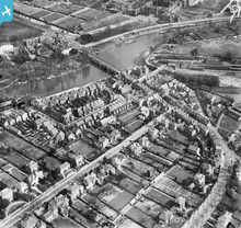
EPW031570 ENGLAND (1930). Palace Road, Hampton Court Bridge and the River Thames, East Molesey, 1930
© Copyright OpenStreetMap contributors and licensed by the OpenStreetMap Foundation. 2026. Cartography is licensed as CC BY-SA.
Nearby Images (10)
Details
| Title | [EPW031570] Palace Road, Hampton Court Bridge and the River Thames, East Molesey, 1930 |
| Reference | EPW031570 |
| Date | February-1930 |
| Link | |
| Place name | EAST MOLESEY |
| Parish | |
| District | |
| Country | ENGLAND |
| Easting / Northing | 515195, 168413 |
| Longitude / Latitude | -0.34375421458484, 51.402539055068 |
| National Grid Reference | TQ152684 |
Pins

Paolo |
Tuesday 12th of April 2016 04:56:31 PM | |

Paolo |
Tuesday 12th of April 2016 04:53:17 PM | |

loweightes |
Tuesday 27th of August 2013 05:18:53 PM | |

loweightes |
Tuesday 27th of August 2013 05:18:07 PM | |

Graham |
Thursday 28th of June 2012 12:03:36 PM | |

Graham |
Thursday 28th of June 2012 12:02:45 PM | |

Graham |
Thursday 28th of June 2012 12:02:07 PM | |

Graham |
Thursday 28th of June 2012 12:00:53 PM | |

Graham |
Thursday 28th of June 2012 12:00:17 PM | |

Graham |
Thursday 28th of June 2012 11:59:14 AM |
User Comment Contributions

SteveB |
Friday 13th of July 2012 11:03:24 AM |


![[EPW031570] Palace Road, Hampton Court Bridge and the River Thames, East Molesey, 1930](http://britainfromabove.org.uk/sites/all/libraries/aerofilms-images/public/100x100/EPW/031/EPW031570.jpg)
![[EPW031567] Bridge Road and Hampton Court Bridge, East Molesey, 1930. This image has been produced from a copy-negative.](http://britainfromabove.org.uk/sites/all/libraries/aerofilms-images/public/100x100/EPW/031/EPW031567.jpg)
![[EPW031575] Hampton Court Bridge and Railway Station, East Molesey, 1930. This image has been produced from a copy-negative.](http://britainfromabove.org.uk/sites/all/libraries/aerofilms-images/public/100x100/EPW/031/EPW031575.jpg)
![[EPW001715] Hampton Court Palace, Bridge and Station, Hampton Court Park, 1920](http://britainfromabove.org.uk/sites/all/libraries/aerofilms-images/public/100x100/EPW/001/EPW001715.jpg)
![[EAW023678] Hampton Court Bridge, Hampton, 1949](http://britainfromabove.org.uk/sites/all/libraries/aerofilms-images/public/100x100/EAW/023/EAW023678.jpg)
![[EPW031569] Hampton Court Bridge and the River Thames, Hampton Court Park, 1930. This image has been produced from a copy-negative.](http://britainfromabove.org.uk/sites/all/libraries/aerofilms-images/public/100x100/EPW/031/EPW031569.jpg)
![[EAW023680] Crowds along the bank of the River Thames at Cigarette Island Park and Hampton Court Bridge, East Molesey, 1949](http://britainfromabove.org.uk/sites/all/libraries/aerofilms-images/public/100x100/EAW/023/EAW023680.jpg)
![[EPW008867] Hampton Court Bridge and the Palace, Hampton Court Park, 1923](http://britainfromabove.org.uk/sites/all/libraries/aerofilms-images/public/100x100/EPW/008/EPW008867.jpg)
![[EPW031565] Hampton Court Bridge and the River Thames, Hampton Court Park, 1930. This image has been produced from a print.](http://britainfromabove.org.uk/sites/all/libraries/aerofilms-images/public/100x100/EPW/031/EPW031565.jpg)
![[EPW049593] The River Thames at Hampton Court Bridge, Taggs Island and environs, East Molesey, 1936. This image has been affected by flare.](http://britainfromabove.org.uk/sites/all/libraries/aerofilms-images/public/100x100/EPW/049/EPW049593.jpg)
