
EPW031203 ENGLAND (1929). The River Thames flood at Royal Windsor Race Course, Windsor, 1929

© Copyright OpenStreetMap contributors and licensed by the OpenStreetMap Foundation. 2026. Cartography is licensed as CC BY-SA.
Nearby Images (7)
EPW031203

EAW003789

EAW026461

EAW026477

EAW026462

EAW026460

EAW026464

Details
| Title | [EPW031203] The River Thames flood at Royal Windsor Race Course, Windsor, 1929 |
| Reference | EPW031203 |
| Date | December-1929 |
| Link | |
| Place name | WINDSOR |
| Parish | |
| District | |
| Country | ENGLAND |
| Easting / Northing | 494638, 177438 |
| Longitude / Latitude | -0.63680424488356, 51.487477795137 |
| National Grid Reference | SU946774 |
Pins
Be the first to add a comment to this image!
User Comment Contributions
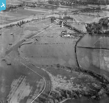
You can see the race track and jumps sticking out of the water. Flood defences including the Thames Barrier have been built since the 1920s as the Thames floods could have flooded large areas of London. |

MM |
Friday 5th of April 2013 12:19:24 PM |