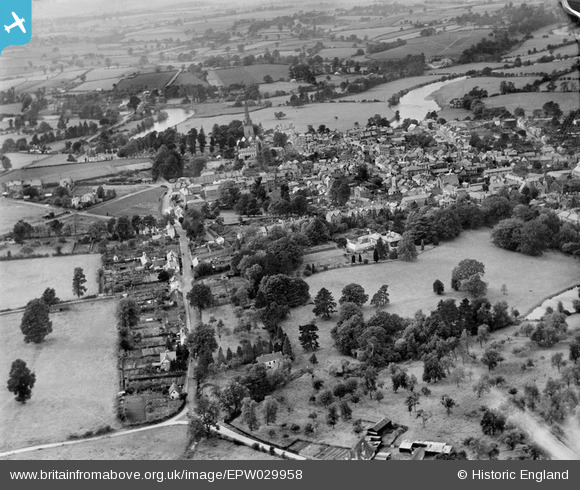
EPW029958 ENGLAND (1929). Alton Street and the town, Ross-on-Wye, from the south-east, 1929
© Copyright OpenStreetMap contributors and licensed by the OpenStreetMap Foundation. 2025. Cartography is licensed as CC BY-SA.
Nearby Images (8)
Details
| Title | [EPW029958] Alton Street and the town, Ross-on-Wye, from the south-east, 1929 |
| Reference | EPW029958 |
| Date | September-1929 |
| Link | |
| Place name | ROSS-ON-WYE |
| Parish | ROSS-ON-WYE |
| District | |
| Country | ENGLAND |
| Easting / Northing | 360361, 223775 |
| Longitude / Latitude | -2.5763138001957, 51.910660654512 |
| National Grid Reference | SO604238 |
Pins

Southdown |
Saturday 10th of May 2014 09:42:54 PM | |

Southdown |
Saturday 10th of May 2014 09:41:53 PM | |

Southdown |
Saturday 10th of May 2014 09:40:50 PM | |

Southdown |
Saturday 10th of May 2014 09:40:09 PM | |

Southdown |
Saturday 10th of May 2014 09:39:19 PM | |

Southdown |
Saturday 10th of May 2014 09:37:54 PM | |

Southdown |
Saturday 10th of May 2014 09:36:27 PM | |

Southdown |
Saturday 10th of May 2014 09:35:57 PM | |

Southdown |
Saturday 10th of May 2014 09:35:09 PM | |

Southdown |
Saturday 10th of May 2014 09:34:33 PM | |

Southdown |
Saturday 10th of May 2014 09:33:29 PM |


![[EPW029958] Alton Street and the town, Ross-on-Wye, from the south-east, 1929](http://britainfromabove.org.uk/sites/all/libraries/aerofilms-images/public/100x100/EPW/029/EPW029958.jpg)
![[EAW040832] The Chase Hotel and environs, Ross-on-Wye, 1951. This image has been produced from a print marked by Aerofilms Ltd for photo editing.](http://britainfromabove.org.uk/sites/all/libraries/aerofilms-images/public/100x100/EAW/040/EAW040832.jpg)
![[EAW040834] The Chase Hotel and environs, Ross-on-Wye, 1951. This image has been produced from a print marked by Aerofilms Ltd for photo editing.](http://britainfromabove.org.uk/sites/all/libraries/aerofilms-images/public/100x100/EAW/040/EAW040834.jpg)
![[EAW040833] The Chase Hotel and environs, Ross-on-Wye, 1951. This image has been produced from a print marked by Aerofilms Ltd for photo editing.](http://britainfromabove.org.uk/sites/all/libraries/aerofilms-images/public/100x100/EAW/040/EAW040833.jpg)
![[EAW040829] The Chase Hotel, Ross-on-Wye, 1951. This image has been produced from a print marked by Aerofilms Ltd for photo editing.](http://britainfromabove.org.uk/sites/all/libraries/aerofilms-images/public/100x100/EAW/040/EAW040829.jpg)
![[EAW040830] The Chase Hotel, Ross-on-Wye, 1951. This image has been produced from a print marked by Aerofilms Ltd for photo editing.](http://britainfromabove.org.uk/sites/all/libraries/aerofilms-images/public/100x100/EAW/040/EAW040830.jpg)
![[EAW040828] The Chase Hotel, Ross-on-Wye, 1951. This image has been produced from a print marked by Aerofilms Ltd for photo editing.](http://britainfromabove.org.uk/sites/all/libraries/aerofilms-images/public/100x100/EAW/040/EAW040828.jpg)
![[EAW040831] The Chase Hotel, Ross-on-Wye, 1951. This image has been produced from a print.](http://britainfromabove.org.uk/sites/all/libraries/aerofilms-images/public/100x100/EAW/040/EAW040831.jpg)