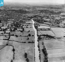
EPW029949 ENGLAND (1929). The River Wye and the city, Hereford, from the west, 1929

© Copyright OpenStreetMap contributors and licensed by the OpenStreetMap Foundation. 2026. Cartography is licensed as CC BY-SA.
Details
| Title | [EPW029949] The River Wye and the city, Hereford, from the west, 1929 |
| Reference | EPW029949 |
| Date | September-1929 |
| Link | |
| Place name | HEREFORD |
| Parish | BREINTON |
| District | |
| Country | ENGLAND |
| Easting / Northing | 349268, 239055 |
| Longitude / Latitude | -2.7398424735004, 52.047143406523 |
| National Grid Reference | SO493391 |
Pins
 |

Simo |
Friday 16th of December 2016 06:30:29 PM |
|
Dr. David Woods |
Friday 5th of February 2016 02:38:07 PM |