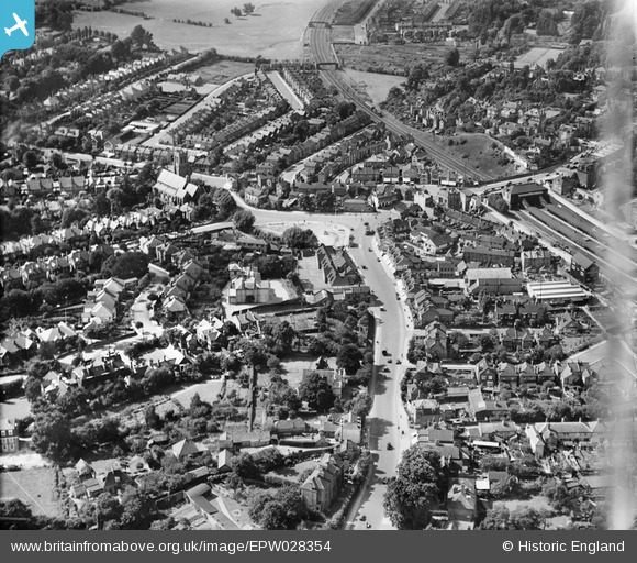
EPW028354 ENGLAND (1929). Masons Hill and environs, Bromley, 1929
© Copyright OpenStreetMap contributors and licensed by the OpenStreetMap Foundation. 2024. Cartography is licensed as CC BY-SA.
Details
| Title | [EPW028354] Masons Hill and environs, Bromley, 1929 |
| Reference | EPW028354 |
| Date | August-1929 |
| Link | |
| Place name | BROMLEY |
| Parish | |
| District | |
| Country | ENGLAND |
| Easting / Northing | 540483, 168553 |
| Longitude / Latitude | 0.01966508942672, 51.398097251824 |
| National Grid Reference | TQ405686 |
Pins
 Class31 |
Saturday 3rd of November 2012 03:56:32 PM | |
 Class31 |
Saturday 3rd of November 2012 03:56:05 PM | |
 Class31 |
Saturday 3rd of November 2012 03:55:22 PM | |
 Class31 |
Saturday 3rd of November 2012 03:54:38 PM | |
 Class31 |
Saturday 3rd of November 2012 03:54:00 PM | |
 Class31 |
Saturday 3rd of November 2012 03:53:35 PM | |
 Class31 |
Saturday 3rd of November 2012 03:53:02 PM | |
 Class31 |
Saturday 3rd of November 2012 03:52:42 PM | |
 Class31 |
Saturday 3rd of November 2012 03:52:18 PM |


![[EPW028354] Masons Hill and environs, Bromley, 1929](http://britainfromabove.org.uk/sites/all/libraries/aerofilms-images/public/100x100/EPW/028/EPW028354.jpg)
![[EPW028352] Masons Hill and environs, Bromley, 1929](http://britainfromabove.org.uk/sites/all/libraries/aerofilms-images/public/100x100/EPW/028/EPW028352.jpg)
![[EPW028342] Bromley South Station and The Broadway, Bromley, 1929](http://britainfromabove.org.uk/sites/all/libraries/aerofilms-images/public/100x100/EPW/028/EPW028342.jpg)