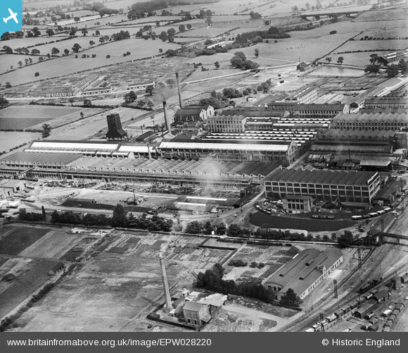
EPW028220 ENGLAND (1929). British Thomson-Houston Electrical Engineering Works, Rugby, 1929
© Copyright OpenStreetMap contributors and licensed by the OpenStreetMap Foundation. 2026. Cartography is licensed as CC BY-SA.
Nearby Images (31)
Details
| Title | [EPW028220] British Thomson-Houston Electrical Engineering Works, Rugby, 1929 |
| Reference | EPW028220 |
| Date | July-1929 |
| Link | |
| Place name | RUGBY |
| Parish | |
| District | |
| Country | ENGLAND |
| Easting / Northing | 450778, 276326 |
| Longitude / Latitude | -1.2538931775963, 52.382229896812 |
| National Grid Reference | SP508763 |
Pins
Be the first to add a comment to this image!


![[EPW028220] British Thomson-Houston Electrical Engineering Works, Rugby, 1929](http://britainfromabove.org.uk/sites/all/libraries/aerofilms-images/public/100x100/EPW/028/EPW028220.jpg)
![[EPW028215] British Thomson-Houston Electrical Engineering Works, Rugby, 1929](http://britainfromabove.org.uk/sites/all/libraries/aerofilms-images/public/100x100/EPW/028/EPW028215.jpg)
![[EPW028218] British Thomson-Houston Electrical Engineering Works, Rugby, 1929](http://britainfromabove.org.uk/sites/all/libraries/aerofilms-images/public/100x100/EPW/028/EPW028218.jpg)
![[EAW001114] British Thomson-Houston Electrical Engineering Works, Rugby, 1946](http://britainfromabove.org.uk/sites/all/libraries/aerofilms-images/public/100x100/EAW/001/EAW001114.jpg)
![[EPW033931] British Thomson-Houston Co Ltd Electrical Engineering Works, Rugby, 1930](http://britainfromabove.org.uk/sites/all/libraries/aerofilms-images/public/100x100/EPW/033/EPW033931.jpg)
![[EAW000245] The British Thomson-Houston Electrical Engineering Works, Rugby, 1946](http://britainfromabove.org.uk/sites/all/libraries/aerofilms-images/public/100x100/EAW/000/EAW000245.jpg)
![[EAW001112] British Thomson-Houston Electrical Engineering Works, Rugby, 1946](http://britainfromabove.org.uk/sites/all/libraries/aerofilms-images/public/100x100/EAW/001/EAW001112.jpg)
![[EAW000239] The British Thomson-Houston Electrical Engineering Works, Rugby, 1946](http://britainfromabove.org.uk/sites/all/libraries/aerofilms-images/public/100x100/EAW/000/EAW000239.jpg)
![[EAW001113] British Thomson-Houston Electrical Engineering Works, Rugby, 1946](http://britainfromabove.org.uk/sites/all/libraries/aerofilms-images/public/100x100/EAW/001/EAW001113.jpg)
![[EPW028222] British Thomson-Houston Electrical Engineering Works, Rugby, 1929](http://britainfromabove.org.uk/sites/all/libraries/aerofilms-images/public/100x100/EPW/028/EPW028222.jpg)
![[EAW000247] The British Thomson-Houston Electrical Engineering Works, Rugby, 1946](http://britainfromabove.org.uk/sites/all/libraries/aerofilms-images/public/100x100/EAW/000/EAW000247.jpg)
![[EPW010529] The British Thomson-Houston Electrical Engineering Works, Rugby, 1924](http://britainfromabove.org.uk/sites/all/libraries/aerofilms-images/public/100x100/EPW/010/EPW010529.jpg)
![[EAW000244] The British Thomson-Houston Electrical Engineering Works, Rugby, 1946](http://britainfromabove.org.uk/sites/all/libraries/aerofilms-images/public/100x100/EAW/000/EAW000244.jpg)
![[EAW001117] British Thomson-Houston Electrical Engineering Works and environs, Rugby, 1946](http://britainfromabove.org.uk/sites/all/libraries/aerofilms-images/public/100x100/EAW/001/EAW001117.jpg)
![[EAW001115] British Thomson-Houston Electrical Engineering Works, Rugby, 1946](http://britainfromabove.org.uk/sites/all/libraries/aerofilms-images/public/100x100/EAW/001/EAW001115.jpg)
![[EAW001118] British Thomson-Houston Electrical Engineering Works, Rugby, 1946](http://britainfromabove.org.uk/sites/all/libraries/aerofilms-images/public/100x100/EAW/001/EAW001118.jpg)
![[EPW028214] British Thomson-Houston Electrical Engineering Works, Rugby, 1929](http://britainfromabove.org.uk/sites/all/libraries/aerofilms-images/public/100x100/EPW/028/EPW028214.jpg)
![[EPW028217] British Thomson-Houston Electrical Engineering Works, Rugby, 1929](http://britainfromabove.org.uk/sites/all/libraries/aerofilms-images/public/100x100/EPW/028/EPW028217.jpg)
![[EAW001116] British Thomson-Houston Electrical Engineering Works, Rugby, 1946](http://britainfromabove.org.uk/sites/all/libraries/aerofilms-images/public/100x100/EAW/001/EAW001116.jpg)
![[EPW028852] The British Thomson-Houston Electrical Engineering Works and environs, Rugby, 1929](http://britainfromabove.org.uk/sites/all/libraries/aerofilms-images/public/100x100/EPW/028/EPW028852.jpg)
![[EPW028216] British Thomson-Houston Electrical Engineering Works, Rugby, 1929](http://britainfromabove.org.uk/sites/all/libraries/aerofilms-images/public/100x100/EPW/028/EPW028216.jpg)
![[EAW000246] The British Thomson-Houston Electrical Engineering Works, Rugby, 1946](http://britainfromabove.org.uk/sites/all/libraries/aerofilms-images/public/100x100/EAW/000/EAW000246.jpg)
![[EPW028221] British Thomson-Houston Electrical Engineering Works, Rugby, 1929](http://britainfromabove.org.uk/sites/all/libraries/aerofilms-images/public/100x100/EPW/028/EPW028221.jpg)
![[EPW001337] The British Thomson-Houston Company Limited, Rugby, 1920](http://britainfromabove.org.uk/sites/all/libraries/aerofilms-images/public/100x100/EPW/001/EPW001337.jpg)
![[EAW000243] The British Thomson-Houston Electrical Engineering Works, Rugby, 1946](http://britainfromabove.org.uk/sites/all/libraries/aerofilms-images/public/100x100/EAW/000/EAW000243.jpg)
![[EPW028855] The British Thomson-Houston Electrical Engineering Works and environs, Rugby, 1929](http://britainfromabove.org.uk/sites/all/libraries/aerofilms-images/public/100x100/EPW/028/EPW028855.jpg)
![[EAW000241] The British Thomson-Houston Electrical Engineering Works, Rugby, 1946](http://britainfromabove.org.uk/sites/all/libraries/aerofilms-images/public/100x100/EAW/000/EAW000241.jpg)
![[EAW000240] The British Thomson-Houston Electrical Engineering Works, Rugby, 1946](http://britainfromabove.org.uk/sites/all/libraries/aerofilms-images/public/100x100/EAW/000/EAW000240.jpg)
![[EPW033934] British Thomson-Houston Co Ltd Electrical Engineering Works, Rugby, from the south-west, 1930](http://britainfromabove.org.uk/sites/all/libraries/aerofilms-images/public/100x100/EPW/033/EPW033934.jpg)
![[EAW000248] The British Thomson-Houston Electrical Engineering Works, Rugby, 1946](http://britainfromabove.org.uk/sites/all/libraries/aerofilms-images/public/100x100/EAW/000/EAW000248.jpg)
![[EPW033932] British Thomson-Houston Co Ltd Electrical Engineering Works, Rugby, from the south-west, 1930](http://britainfromabove.org.uk/sites/all/libraries/aerofilms-images/public/100x100/EPW/033/EPW033932.jpg)