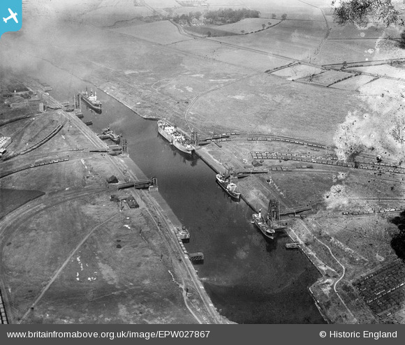
EPW027867 ENGLAND (1929). The Manchester Ship Canal and the Partington Coal Basin, Partington, 1929
© Copyright OpenStreetMap contributors and licensed by the OpenStreetMap Foundation. 2026. Cartography is licensed as CC BY-SA.
Nearby Images (11)
Details
| Title | [EPW027867] The Manchester Ship Canal and the Partington Coal Basin, Partington, 1929 |
| Reference | EPW027867 |
| Date | June-1929 |
| Link | |
| Place name | PARTINGTON |
| Parish | PARTINGTON |
| District | |
| Country | ENGLAND |
| Easting / Northing | 372048, 392330 |
| Longitude / Latitude | -2.4207091952393, 53.426761476079 |
| National Grid Reference | SJ720923 |
Pins
Be the first to add a comment to this image!


![[EPW027867] The Manchester Ship Canal and the Partington Coal Basin, Partington, 1929](http://britainfromabove.org.uk/sites/all/libraries/aerofilms-images/public/100x100/EPW/027/EPW027867.jpg)
![[EPW027868] The Manchester Ship Canal and the Partington Coal Basin, Partington, 1929](http://britainfromabove.org.uk/sites/all/libraries/aerofilms-images/public/100x100/EPW/027/EPW027868.jpg)
![[EPW027871] The Manchester Ship Canal and the Partington Coal Basin, Partington, 1929](http://britainfromabove.org.uk/sites/all/libraries/aerofilms-images/public/100x100/EPW/027/EPW027871.jpg)
![[EPW027869] The Manchester Ship Canal and the Partington Coal Basin, Partington, 1929](http://britainfromabove.org.uk/sites/all/libraries/aerofilms-images/public/100x100/EPW/027/EPW027869.jpg)
![[EAW009438] Ship Canal Sidings and tank by Partington Coal Basin, Partington, from the north, 1947. This image has been produced from a print.](http://britainfromabove.org.uk/sites/all/libraries/aerofilms-images/public/100x100/EAW/009/EAW009438.jpg)
![[EAW009450] Ship Canal Sidings and tank by Partington Coal Basin, Partington, 1947. This image has been produced from a print.](http://britainfromabove.org.uk/sites/all/libraries/aerofilms-images/public/100x100/EAW/009/EAW009450.jpg)
![[EAW009439] Ship Canal Sidings and tank by Partington Coal Basin, Partington, 1947. This image has been produced from a print.](http://britainfromabove.org.uk/sites/all/libraries/aerofilms-images/public/100x100/EAW/009/EAW009439.jpg)
![[EAW009436] Ship Canal Sidings and tank by Partington Coal Basin, Partington, 1947. This image has been produced from a print.](http://britainfromabove.org.uk/sites/all/libraries/aerofilms-images/public/100x100/EAW/009/EAW009436.jpg)
![[EAW009437] The Irlam Works, Ship Canal Sidings and tank by Partington Coal Basin, Partington, 1947. This image has been produced from a print.](http://britainfromabove.org.uk/sites/all/libraries/aerofilms-images/public/100x100/EAW/009/EAW009437.jpg)
![[EAW009435] Ship Canal Sidings and tank by Partington Coal Basin, Partington, from the north-east, 1947. This image has been produced from a print.](http://britainfromabove.org.uk/sites/all/libraries/aerofilms-images/public/100x100/EAW/009/EAW009435.jpg)
![[EAW009432] Ship Canal Sidings and tank by Partington Coal Basin, Partington, 1947. This image has been produced from a print.](http://britainfromabove.org.uk/sites/all/libraries/aerofilms-images/public/100x100/EAW/009/EAW009432.jpg)