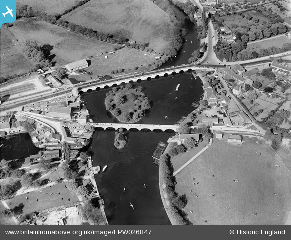
EPW026847 ENGLAND (1929). Clopton Bridge, Stratford-upon-Avon, 1929
© Copyright OpenStreetMap contributors and licensed by the OpenStreetMap Foundation. 2026. Cartography is licensed as CC BY-SA.
Nearby Images (30)
Details
| Title | [EPW026847] Clopton Bridge, Stratford-upon-Avon, 1929 |
| Reference | EPW026847 |
| Date | May-1929 |
| Link | |
| Place name | STRATFORD-UPON-AVON |
| Parish | STRATFORD-UPON-AVON |
| District | |
| Country | ENGLAND |
| Easting / Northing | 420529, 254806 |
| Longitude / Latitude | -1.6996567138509, 52.190709551111 |
| National Grid Reference | SP205548 |
Pins

John W |
Wednesday 20th of November 2019 06:06:55 PM | |

gord |
Tuesday 21st of July 2015 07:29:13 AM | |

gord |
Tuesday 21st of July 2015 07:28:40 AM | |

Fantasma |
Saturday 20th of October 2012 09:18:20 PM | |

Fantasma |
Saturday 20th of October 2012 09:17:28 PM | |

Fantasma |
Saturday 20th of October 2012 09:16:36 PM |


![[EPW026847] Clopton Bridge, Stratford-upon-Avon, 1929](http://britainfromabove.org.uk/sites/all/libraries/aerofilms-images/public/100x100/EPW/026/EPW026847.jpg)
![[EPW026848] Clopton Bridge and environs, Stratford-upon-Avon, 1929](http://britainfromabove.org.uk/sites/all/libraries/aerofilms-images/public/100x100/EPW/026/EPW026848.jpg)
![[EAW006662] Clopton Bridge and the Shakespeare Memorial Theatre, Stratford-upon-Avon, 1947](http://britainfromabove.org.uk/sites/all/libraries/aerofilms-images/public/100x100/EAW/006/EAW006662.jpg)
![[EPW037628] Clopton Bridge, Bridge Foot and environs, Stratford-upon-Avon, 1932](http://britainfromabove.org.uk/sites/all/libraries/aerofilms-images/public/100x100/EPW/037/EPW037628.jpg)
![[EAW006663] The Bancroft and the Shakespeare Memorial Theatre, Stratford-upon-Avon, 1947](http://britainfromabove.org.uk/sites/all/libraries/aerofilms-images/public/100x100/EAW/006/EAW006663.jpg)
![[EPW026838] The Bancroft and Royal Shakespeare Theatre, Stratford-upon-Avon, 1929](http://britainfromabove.org.uk/sites/all/libraries/aerofilms-images/public/100x100/EPW/026/EPW026838.jpg)
![[EAW025671] Clopton Bridge, the River Avon, Royal Shakespeare Theatre and environs, Stratford-upon-Avon, from the north-east, 1949. This image has been produced from a print.](http://britainfromabove.org.uk/sites/all/libraries/aerofilms-images/public/100x100/EAW/025/EAW025671.jpg)
![[EAW006658] The town centre, Stratford-upon-Avon, from the north-east, 1947](http://britainfromabove.org.uk/sites/all/libraries/aerofilms-images/public/100x100/EAW/006/EAW006658.jpg)
![[EPW053207] The town, Stratford-upon-Avon, from the south-east, 1937](http://britainfromabove.org.uk/sites/all/libraries/aerofilms-images/public/100x100/EPW/053/EPW053207.jpg)
![[EPW053202] The Shakespeare Memorial Theatre and The Bancroft, Stratford-upon-Avon, 1937](http://britainfromabove.org.uk/sites/all/libraries/aerofilms-images/public/100x100/EPW/053/EPW053202.jpg)
![[EPW037591] The Shakespeare Memorial Theatre, Stratford-upon-Avon, 1932](http://britainfromabove.org.uk/sites/all/libraries/aerofilms-images/public/100x100/EPW/037/EPW037591.jpg)
![[EPW037594] The Shakespeare Memorial Theatre, Stratford-upon-Avon, 1932. This image has been produced from a damaged negative.](http://britainfromabove.org.uk/sites/all/libraries/aerofilms-images/public/100x100/EPW/037/EPW037594.jpg)
![[EPW053203] The Shakespeare Memorial Theatre and The Bancroft, Stratford-upon-Avon, 1937](http://britainfromabove.org.uk/sites/all/libraries/aerofilms-images/public/100x100/EPW/053/EPW053203.jpg)
![[EPW037593] The Shakespeare Memorial Theatre, Stratford-upon-Avon, 1932](http://britainfromabove.org.uk/sites/all/libraries/aerofilms-images/public/100x100/EPW/037/EPW037593.jpg)
![[EPR000081] The Shakespeare Memorial Theatre (Royal Shakespeare Theatre), Stratford-upon-Avon, 1934. This image has been produced from a damaged negative.](http://britainfromabove.org.uk/sites/all/libraries/aerofilms-images/public/100x100/EPR/000/EPR000081.jpg)
![[EAW006661] The cricket ground and the town, Stratford-upon-Avon, from the south-east, 1947](http://britainfromabove.org.uk/sites/all/libraries/aerofilms-images/public/100x100/EAW/006/EAW006661.jpg)
![[EAW013453] The Royal Shakespeare Theatre, Stratford-upon-Avon, 1948](http://britainfromabove.org.uk/sites/all/libraries/aerofilms-images/public/100x100/EAW/013/EAW013453.jpg)
![[EPW014650] The Shakespeare Memorial Theatre, Waterside and environs, Stratford-upon-Avon, 1925. This image has been produced from a copy-negative.](http://britainfromabove.org.uk/sites/all/libraries/aerofilms-images/public/100x100/EPW/014/EPW014650.jpg)
![[EAW006656] The town centre, Stratford-upon-Avon, from the south-east, 1947](http://britainfromabove.org.uk/sites/all/libraries/aerofilms-images/public/100x100/EAW/006/EAW006656.jpg)
![[EAW044239] The Royal Shakespeare Theatre and the town centre, Stratford-upon-Avon, 1952](http://britainfromabove.org.uk/sites/all/libraries/aerofilms-images/public/100x100/EAW/044/EAW044239.jpg)
![[EPW037592] The Shakespeare Memorial Theatre, Stratford-upon-Avon, 1932](http://britainfromabove.org.uk/sites/all/libraries/aerofilms-images/public/100x100/EPW/037/EPW037592.jpg)
![[EPR000580] The town and Shakespeare Memorial Theatre, Stratford-upon-Avon, 1935. This image was marked by Aero Pictorial Ltd for photo editing.](http://britainfromabove.org.uk/sites/all/libraries/aerofilms-images/public/100x100/EPR/000/EPR000580.jpg)
![[EAW013452] The Royal Shakespeare Theatre, Stratford-upon-Avon, 1948](http://britainfromabove.org.uk/sites/all/libraries/aerofilms-images/public/100x100/EAW/013/EAW013452.jpg)
![[EAW013451] The Royal Shakespeare Theatre, Stratford-upon-Avon, 1948](http://britainfromabove.org.uk/sites/all/libraries/aerofilms-images/public/100x100/EAW/013/EAW013451.jpg)
![[EAW044237] The Royal Shakespeare Theatre and the town, Stratford-upon-Avon, 1952](http://britainfromabove.org.uk/sites/all/libraries/aerofilms-images/public/100x100/EAW/044/EAW044237.jpg)
![[EPR000082] The Shakespeare Memorial Theatre (Royal Shakespeare Theatre), Stratford-upon-Avon, 1934](http://britainfromabove.org.uk/sites/all/libraries/aerofilms-images/public/100x100/EPR/000/EPR000082.jpg)
![[EAW003576] The town, Stratford-upon-Avon, from the south-east, 1947](http://britainfromabove.org.uk/sites/all/libraries/aerofilms-images/public/100x100/EAW/003/EAW003576.jpg)
![[EAW025672] The Royal Shakespeare Theatre and environs, Stratford-upon-Avon, from the south-east, 1949. This image has been produced from a print.](http://britainfromabove.org.uk/sites/all/libraries/aerofilms-images/public/100x100/EAW/025/EAW025672.jpg)
![[EPW053206] Sheep Street and environs, Stratford-upon-Avon, 1937](http://britainfromabove.org.uk/sites/all/libraries/aerofilms-images/public/100x100/EPW/053/EPW053206.jpg)
![[EPW026837] Bridge Street and environs, Stratford-upon-Avon, 1929](http://britainfromabove.org.uk/sites/all/libraries/aerofilms-images/public/100x100/EPW/026/EPW026837.jpg)