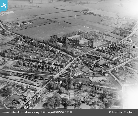
EPW026818 ENGLAND (1929). The Friends' School and environs, Saffron Walden, 1929
© Copyright OpenStreetMap contributors and licensed by the OpenStreetMap Foundation. 2026. Cartography is licensed as CC BY-SA.
Nearby Images (14)
Details
| Title | [EPW026818] The Friends' School and environs, Saffron Walden, 1929 |
| Reference | EPW026818 |
| Date | May-1929 |
| Link | |
| Place name | SAFFRON WALDEN |
| Parish | SAFFRON WALDEN |
| District | |
| Country | ENGLAND |
| Easting / Northing | 553886, 237767 |
| Longitude / Latitude | 0.24276476411377, 52.016534400091 |
| National Grid Reference | TL539378 |
Pins

CharlesA |
Thursday 22nd of August 2024 09:53:14 PM | |

Kate |
Wednesday 15th of April 2015 09:53:50 PM | |

Kate |
Wednesday 15th of April 2015 09:41:43 PM | |

Kate |
Wednesday 15th of April 2015 09:41:10 PM |


![[EPW026818] The Friends' School and environs, Saffron Walden, 1929](http://britainfromabove.org.uk/sites/all/libraries/aerofilms-images/public/100x100/EPW/026/EPW026818.jpg)
![[EPW026832] The Friends' School, Saffron Walden, 1929](http://britainfromabove.org.uk/sites/all/libraries/aerofilms-images/public/100x100/EPW/026/EPW026832.jpg)
![[EPW026826] The Friends' School, Saffron Walden, 1929](http://britainfromabove.org.uk/sites/all/libraries/aerofilms-images/public/100x100/EPW/026/EPW026826.jpg)
![[EPW026819] The Friends' School and environs, Saffron Walden, 1929](http://britainfromabove.org.uk/sites/all/libraries/aerofilms-images/public/100x100/EPW/026/EPW026819.jpg)
![[EPW025914] The Friends' School, Saffron Walden, 1929](http://britainfromabove.org.uk/sites/all/libraries/aerofilms-images/public/100x100/EPW/025/EPW025914.jpg)
![[EPW026828] The Friends' School, Saffron Walden, 1929](http://britainfromabove.org.uk/sites/all/libraries/aerofilms-images/public/100x100/EPW/026/EPW026828.jpg)
![[EPW026820] The Friends' School and environs, Saffron Walden, 1929](http://britainfromabove.org.uk/sites/all/libraries/aerofilms-images/public/100x100/EPW/026/EPW026820.jpg)
![[EPW026836] The Friends' School and environs, Saffron Walden, 1929](http://britainfromabove.org.uk/sites/all/libraries/aerofilms-images/public/100x100/EPW/026/EPW026836.jpg)
![[EPW026833] The Friends' School and environs, Saffron Walden, 1929](http://britainfromabove.org.uk/sites/all/libraries/aerofilms-images/public/100x100/EPW/026/EPW026833.jpg)
![[EPW026817] The Friends' School, Saffron Walden, 1929](http://britainfromabove.org.uk/sites/all/libraries/aerofilms-images/public/100x100/EPW/026/EPW026817.jpg)
![[EPW026835] The Friends' School and environs, Saffron Walden, 1929](http://britainfromabove.org.uk/sites/all/libraries/aerofilms-images/public/100x100/EPW/026/EPW026835.jpg)
![[EPW026821] The Friends' School, Saffron Walden, 1929](http://britainfromabove.org.uk/sites/all/libraries/aerofilms-images/public/100x100/EPW/026/EPW026821.jpg)
![[EPW025910] The town, Saffron Walden, from the south, 1929](http://britainfromabove.org.uk/sites/all/libraries/aerofilms-images/public/100x100/EPW/025/EPW025910.jpg)
![[EPW026830] The Friends' School, Saffron Walden, 1929](http://britainfromabove.org.uk/sites/all/libraries/aerofilms-images/public/100x100/EPW/026/EPW026830.jpg)