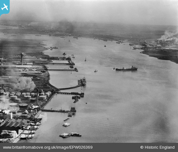
EPW026369 ENGLAND (1929). Purfleet Wharf, Caspian Wharf and the River Thames, Purfleet, from the north-west, 1929
© Copyright OpenStreetMap contributors and licensed by the OpenStreetMap Foundation. 2026. Cartography is licensed as CC BY-SA.
Nearby Images (16)
Details
| Title | [EPW026369] Purfleet Wharf, Caspian Wharf and the River Thames, Purfleet, from the north-west, 1929 |
| Reference | EPW026369 |
| Date | April-1929 |
| Link | |
| Place name | PURFLEET |
| Parish | |
| District | |
| Country | ENGLAND |
| Easting / Northing | 556037, 177227 |
| Longitude / Latitude | 0.24692565653374, 51.47197397235 |
| National Grid Reference | TQ560772 |
Pins
Be the first to add a comment to this image!


![[EPW026369] Purfleet Wharf, Caspian Wharf and the River Thames, Purfleet, from the north-west, 1929](http://britainfromabove.org.uk/sites/all/libraries/aerofilms-images/public/100x100/EPW/026/EPW026369.jpg)
![[EAW024360] The Hunting and Son Ltd oil tanker "Edenfield" moored at the Esso pier, Purfleet, 1949](http://britainfromabove.org.uk/sites/all/libraries/aerofilms-images/public/100x100/EAW/024/EAW024360.jpg)
![[EAW024363] The Hunting and Son Ltd oil tanker "Edenfield" moored at the Esso pier, Purfleet, 1949](http://britainfromabove.org.uk/sites/all/libraries/aerofilms-images/public/100x100/EAW/024/EAW024363.jpg)
![[EAW023164] Tanker moored by the Esso Oil Depot, Purfleet, 1949](http://britainfromabove.org.uk/sites/all/libraries/aerofilms-images/public/100x100/EAW/023/EAW023164.jpg)
![[EAW024359] The Hunting and Son Ltd oil tanker "Edenfield" moored at the Esso pier, Purfleet, 1949. This image has been produced from a damaged negative.](http://britainfromabove.org.uk/sites/all/libraries/aerofilms-images/public/100x100/EAW/024/EAW024359.jpg)
![[EAW024364] The Hunting and Son Ltd oil tanker "Edenfield" moored at the Esso pier, Purfleet, from the south-west, 1949. This image was marked by Aerofilms Ltd for photo editing.](http://britainfromabove.org.uk/sites/all/libraries/aerofilms-images/public/100x100/EAW/024/EAW024364.jpg)
![[EAW024369] The Hunting and Son Ltd oil tanker "Edenfield" moored at the Esso pier, Purfleet, from the south-west, 1949](http://britainfromabove.org.uk/sites/all/libraries/aerofilms-images/public/100x100/EAW/024/EAW024369.jpg)
![[EAW024367] The Hunting and Son Ltd oil tanker "Edenfield" moored at the Esso pier, Purfleet, 1949](http://britainfromabove.org.uk/sites/all/libraries/aerofilms-images/public/100x100/EAW/024/EAW024367.jpg)
![[EAW023047] A tanker moored at the Esso Oil Depot, Purfleet, 1949](http://britainfromabove.org.uk/sites/all/libraries/aerofilms-images/public/100x100/EAW/023/EAW023047.jpg)
![[EAW024368] The Hunting and Son Ltd oil tanker "Edenfield" moored at the Esso pier, Purfleet, 1949](http://britainfromabove.org.uk/sites/all/libraries/aerofilms-images/public/100x100/EAW/024/EAW024368.jpg)
![[EAW024366] The Hunting and Son Ltd oil tanker "Edenfield" moored at the Esso pier, Purfleet, 1949](http://britainfromabove.org.uk/sites/all/libraries/aerofilms-images/public/100x100/EAW/024/EAW024366.jpg)
![[EPW011905] The Anglo-American Oil Co Ltd Works at Purfleet, Thurrock, 1924. This image has been produced from a print.](http://britainfromabove.org.uk/sites/all/libraries/aerofilms-images/public/100x100/EPW/011/EPW011905.jpg)
![[EAW024365] The Hunting and Son Ltd oil tanker "Edenfield" moored at the Esso pier, Purfleet, 1949](http://britainfromabove.org.uk/sites/all/libraries/aerofilms-images/public/100x100/EAW/024/EAW024365.jpg)
![[EAW048218] Flooding at the Esso Petroleum Co Ltd Terminal, Purfleet, from the south-west, 1953](http://britainfromabove.org.uk/sites/all/libraries/aerofilms-images/public/100x100/EAW/048/EAW048218.jpg)
![[EPW006266] Anglo Americam Oil Company, Purfleet, 1921](http://britainfromabove.org.uk/sites/all/libraries/aerofilms-images/public/100x100/EPW/006/EPW006266.jpg)
![[EAW024361] The Hunting and Son Ltd oil tanker "Edenfield" moored at the Esso pier, Purfleet, 1949](http://britainfromabove.org.uk/sites/all/libraries/aerofilms-images/public/100x100/EAW/024/EAW024361.jpg)