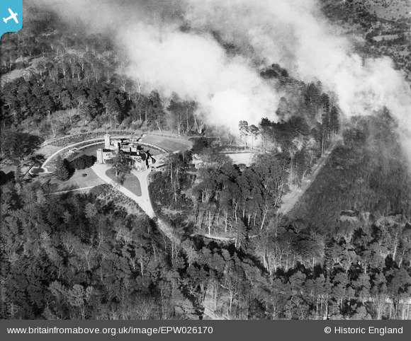
EPW026170 ENGLAND (1929). Fort Belvedere and wild fire in Belvedere Wood, Shrubs Hill, 1929
© Copyright OpenStreetMap contributors and licensed by the OpenStreetMap Foundation. 2025. Cartography is licensed as CC BY-SA.
Nearby Images (9)
Details
| Title | [EPW026170] Fort Belvedere and wild fire in Belvedere Wood, Shrubs Hill, 1929 |
| Reference | EPW026170 |
| Date | 19-April-1929 |
| Link | |
| Place name | SHRUBS HILL |
| Parish | |
| District | |
| Country | ENGLAND |
| Easting / Northing | 496646, 168156 |
| Longitude / Latitude | -0.61042490483826, 51.40369348764 |
| National Grid Reference | SU966682 |
Pins
Be the first to add a comment to this image!


![[EPW026170] Fort Belvedere and wild fire in Belvedere Wood, Shrubs Hill, 1929](http://britainfromabove.org.uk/sites/all/libraries/aerofilms-images/public/100x100/EPW/026/EPW026170.jpg)
![[EPW046523] Fort Belvedere, Wentworth, 1935](http://britainfromabove.org.uk/sites/all/libraries/aerofilms-images/public/100x100/EPW/046/EPW046523.jpg)
![[EPW053893] Fort Belvedere, Wentworth, 1937](http://britainfromabove.org.uk/sites/all/libraries/aerofilms-images/public/100x100/EPW/053/EPW053893.jpg)
![[EPW053892] Fort Belvedere and Belvedere Wood, Wentworth, 1937](http://britainfromabove.org.uk/sites/all/libraries/aerofilms-images/public/100x100/EPW/053/EPW053892.jpg)
![[EPW046525] Fort Belvedere and surroundings, Wentworth, 1935](http://britainfromabove.org.uk/sites/all/libraries/aerofilms-images/public/100x100/EPW/046/EPW046525.jpg)
![[EPW026173] Fort Belvedere and wild fire in Belvedere Wood, Shrubs Hill, 1929](http://britainfromabove.org.uk/sites/all/libraries/aerofilms-images/public/100x100/EPW/026/EPW026173.jpg)
![[EPW026171] Fort Belvedere and wild fire in Belvedere Wood, Shrubs Hill, 1929](http://britainfromabove.org.uk/sites/all/libraries/aerofilms-images/public/100x100/EPW/026/EPW026171.jpg)
![[EPW026172] Wild fire in Belvedere Wood, Shrubs Hill, 1929](http://britainfromabove.org.uk/sites/all/libraries/aerofilms-images/public/100x100/EPW/026/EPW026172.jpg)
![[EPW001652] View over the Royal Estate at Virginia Water from Fort Beveldere, Virginia Water, from the south, 1920](http://britainfromabove.org.uk/sites/all/libraries/aerofilms-images/public/100x100/EPW/001/EPW001652.jpg)