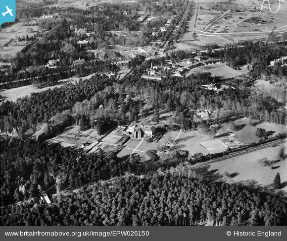
EPW026150 ENGLAND (1929). Englemere House and environs, Ascot, 1929
© Copyright OpenStreetMap contributors and licensed by the OpenStreetMap Foundation. 2026. Cartography is licensed as CC BY-SA.
Nearby Images (6)
Details
| Title | [EPW026150] Englemere House and environs, Ascot, 1929 |
| Reference | EPW026150 |
| Date | April-1929 |
| Link | |
| Place name | ASCOT |
| Parish | SUNNINGHILL AND ASCOT |
| District | |
| Country | ENGLAND |
| Easting / Northing | 491144, 168491 |
| Longitude / Latitude | -0.68942358931515, 51.40761631516 |
| National Grid Reference | SU911685 |
Pins

NJH |
Tuesday 12th of April 2016 06:43:51 PM | |

flubber |
Monday 7th of December 2015 02:12:11 PM | |

flubber |
Monday 7th of December 2015 02:09:44 PM | |

flubber |
Monday 7th of December 2015 02:09:11 PM | |

flubber |
Monday 7th of December 2015 02:07:16 PM |


![[EPW026150] Englemere House and environs, Ascot, 1929](http://britainfromabove.org.uk/sites/all/libraries/aerofilms-images/public/100x100/EPW/026/EPW026150.jpg)
![[EPW026151] Englemere House, Ascot, 1929](http://britainfromabove.org.uk/sites/all/libraries/aerofilms-images/public/100x100/EPW/026/EPW026151.jpg)
![[EPW026148] Englemere House, Ascot, 1929](http://britainfromabove.org.uk/sites/all/libraries/aerofilms-images/public/100x100/EPW/026/EPW026148.jpg)
![[EPW026143] Englemere House, Ascot, 1929](http://britainfromabove.org.uk/sites/all/libraries/aerofilms-images/public/100x100/EPW/026/EPW026143.jpg)
![[EPW026144] Englemere House, Ascot, 1929](http://britainfromabove.org.uk/sites/all/libraries/aerofilms-images/public/100x100/EPW/026/EPW026144.jpg)
![[EPW036161] Heatherwood Hospital, Ascot, 1931](http://britainfromabove.org.uk/sites/all/libraries/aerofilms-images/public/100x100/EPW/036/EPW036161.jpg)