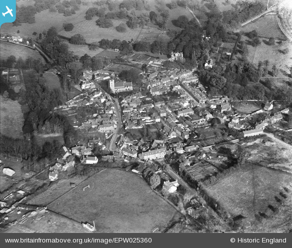
EPW025360 ENGLAND (1928). The village centre, Welwyn, 1928
© Copyright OpenStreetMap contributors and licensed by the OpenStreetMap Foundation. 2025. Cartography is licensed as CC BY-SA.
Details
| Title | [EPW025360] The village centre, Welwyn, 1928 |
| Reference | EPW025360 |
| Date | November-1928 |
| Link | |
| Place name | WELWYN |
| Parish | WELWYN |
| District | |
| Country | ENGLAND |
| Easting / Northing | 523118, 216159 |
| Longitude / Latitude | -0.21311777747785, 51.830015084309 |
| National Grid Reference | TL231162 |
Pins
 womble |
Monday 30th of November 2015 05:11:56 PM | |
 David960 |
Thursday 5th of February 2015 11:42:20 PM | |
 Chells809 |
Monday 6th of May 2013 10:20:23 PM | |
 Chells809 |
Monday 31st of December 2012 12:02:29 PM | |
 Chells809 |
Monday 31st of December 2012 12:01:15 PM | |
 Chells809 |
Monday 31st of December 2012 11:58:59 AM | |
 Chells809 |
Friday 28th of December 2012 05:22:04 PM | |
 Chells809 |
Friday 28th of December 2012 05:21:09 PM | |
 Chells809 |
Friday 28th of December 2012 05:19:48 PM | |
 Chells809 |
Thursday 8th of November 2012 09:37:08 PM | |
 Chells809 |
Thursday 8th of November 2012 09:35:03 PM | |
 Chells809 |
Tuesday 16th of October 2012 09:36:57 PM | |
 Chells809 |
Tuesday 16th of October 2012 09:32:59 PM | |
 Chells809 |
Tuesday 16th of October 2012 09:27:28 PM | |
 Chells809 |
Tuesday 16th of October 2012 09:24:50 PM | |
 Chells809 |
Tuesday 16th of October 2012 09:23:52 PM | |
I think this is actually Welwyn Hall,which ended its days as a research site for Rank Xerox and then the Welwyn Hall Research Centre. It was demolished in the 70s and developed for housing, now Welwyn Hall Gradens |
 Paul |
Friday 22nd of March 2013 10:11:25 AM |
yes this was occupied by rank zerox, until around 87? the site sat derelict for some time until it burnt down around 1991? dansbury would be out of the picture northwards. |
 andrew |
Wednesday 16th of September 2015 12:00:23 PM |
 Chells809 |
Tuesday 16th of October 2012 09:23:08 PM |
User Comment Contributions
A great picture of the centre of Old Welwyn village, about 2-3 miles north-west of what was then the 'new town' of Welwyn Garden City. The main A1 Great North Road ran through the village until c1927 before a new by-pass was built slightly to the east. |
 Chells809 |
Thursday 19th of September 2013 11:07:00 AM |
It was only for a few years; the A1 was designated as such in the early 1920s. The Welwyn ByPass is visible top right. |
 Hugh Madgin |
Thursday 19th of September 2013 11:07:00 AM |


![[EPW025360] The village centre, Welwyn, 1928](http://britainfromabove.org.uk/sites/all/libraries/aerofilms-images/public/100x100/EPW/025/EPW025360.jpg)
![[EPW025495] The village, Welwyn, 1928. This image has been produced from a copy-negative.](http://britainfromabove.org.uk/sites/all/libraries/aerofilms-images/public/100x100/EPW/025/EPW025495.jpg)
![[EPW025496] St Mary's Church and the village, Welwyn, 1928. This image has been produced from a copy-negative.](http://britainfromabove.org.uk/sites/all/libraries/aerofilms-images/public/100x100/EPW/025/EPW025496.jpg)
![[EPW025359] The village and surrounding countryside, Welwyn, from the south-east, 1928](http://britainfromabove.org.uk/sites/all/libraries/aerofilms-images/public/100x100/EPW/025/EPW025359.jpg)