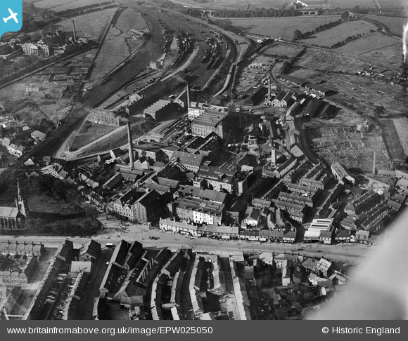
EPW025050 ENGLAND (1928). The Carr and Co Biscuit Factory, Carlisle, 1928
© Copyright OpenStreetMap contributors and licensed by the OpenStreetMap Foundation. 2026. Cartography is licensed as CC BY-SA.
Nearby Images (12)
Details
| Title | [EPW025050] The Carr and Co Biscuit Factory, Carlisle, 1928 |
| Reference | EPW025050 |
| Date | 12-October-1928 |
| Link | |
| Place name | CARLISLE |
| Parish | |
| District | |
| Country | ENGLAND |
| Easting / Northing | 339240, 555970 |
| Longitude / Latitude | -2.94746835615, 54.894681254697 |
| National Grid Reference | NY392560 |
Pins

roger freeman |
Wednesday 29th of August 2012 09:24:51 PM | |

roger freeman |
Wednesday 29th of August 2012 09:10:35 PM | |

roger freeman |
Wednesday 29th of August 2012 09:07:08 PM | |

roger freeman |
Wednesday 29th of August 2012 09:03:53 PM | |

roger freeman |
Wednesday 29th of August 2012 08:56:52 PM | |

roger freeman |
Wednesday 29th of August 2012 08:54:55 PM | |

roger freeman |
Wednesday 29th of August 2012 08:51:04 PM | |

roger freeman |
Wednesday 29th of August 2012 08:38:03 PM | |

roger freeman |
Wednesday 29th of August 2012 07:46:56 PM | |
N. Waterway ? Too cryptic for this Southerner !? |

gBr |
Wednesday 3rd of December 2014 04:37:31 PM |

roger freeman |
Wednesday 29th of August 2012 07:36:05 PM |


![[EPW025050] The Carr and Co Biscuit Factory, Carlisle, 1928](http://britainfromabove.org.uk/sites/all/libraries/aerofilms-images/public/100x100/EPW/025/EPW025050.jpg)
![[EPW025055] The Carr and Co Biscuit Factory and Holy Trinity Church, Carlisle, 1928](http://britainfromabove.org.uk/sites/all/libraries/aerofilms-images/public/100x100/EPW/025/EPW025055.jpg)
![[EPW014300] Church Street and Carr's Biscuit Factory, Carlisle, 1925. This image has been produced from a print.](http://britainfromabove.org.uk/sites/all/libraries/aerofilms-images/public/100x100/EPW/014/EPW014300.jpg)
![[EPW025049] The Carr and Co Biscuit Factory, Carlisle, 1928. This image has been produced from a print.](http://britainfromabove.org.uk/sites/all/libraries/aerofilms-images/public/100x100/EPW/025/EPW025049.jpg)
![[EPW025051] The Carr and Co Biscuit Factory, Carlisle, 1928](http://britainfromabove.org.uk/sites/all/libraries/aerofilms-images/public/100x100/EPW/025/EPW025051.jpg)
![[EPW025048] The Carr and Co Biscuit Factory, Carlisle, 1928](http://britainfromabove.org.uk/sites/all/libraries/aerofilms-images/public/100x100/EPW/025/EPW025048.jpg)
![[EPW025053] The Carr and Co Biscuit Factory, Carlisle, 1928](http://britainfromabove.org.uk/sites/all/libraries/aerofilms-images/public/100x100/EPW/025/EPW025053.jpg)
![[EPW025047] The Carr and Co Biscuit Factory and Holy Trinity Church, Carlisle, 1928](http://britainfromabove.org.uk/sites/all/libraries/aerofilms-images/public/100x100/EPW/025/EPW025047.jpg)
![[EPW025054] The Carr and Co Biscuit Factory and Holy Trinity Church, Carlisle, 1928](http://britainfromabove.org.uk/sites/all/libraries/aerofilms-images/public/100x100/EPW/025/EPW025054.jpg)
![[EPW025052] The Carr and Co Biscuit Factory and Holy Trinity Church, Carlisle, 1928](http://britainfromabove.org.uk/sites/all/libraries/aerofilms-images/public/100x100/EPW/025/EPW025052.jpg)
![[EPW014360] Holy Trinity Church and Carr's Biscuit Factory, Carlisle, 1925. This image has been produced from a print.](http://britainfromabove.org.uk/sites/all/libraries/aerofilms-images/public/100x100/EPW/014/EPW014360.jpg)
![[EPW014372] The Shaddon Mill and environs, Carlisle, 1925](http://britainfromabove.org.uk/sites/all/libraries/aerofilms-images/public/100x100/EPW/014/EPW014372.jpg)