
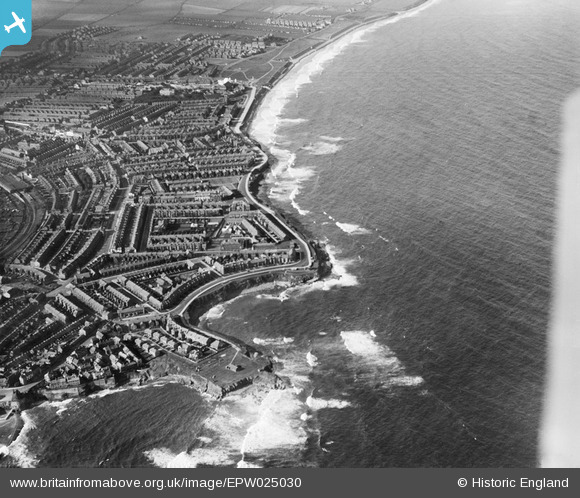
EPW025030 ENGLAND (1928). Brown's Bay, Whitley Bay, from the south-east, 1928
© Copyright OpenStreetMap contributors and licensed by the OpenStreetMap Foundation. 2026. Cartography is licensed as CC BY-SA.
Nearby Images (3)
EPW025030

EAW022859

EAW022858

Details
| Title | [EPW025030] Brown's Bay, Whitley Bay, from the south-east, 1928 |
| Reference | EPW025030 |
| Date | 12-October-1928 |
| Link | |
| Place name | WHITLEY BAY |
| Parish | |
| District | |
| Country | ENGLAND |
| Easting / Northing | 436544, 571845 |
| Longitude / Latitude | -1.42809572063, 55.039704604988 |
| National Grid Reference | NZ365718 |
Pins

John Wass |
Wednesday 21st of June 2017 07:29:57 PM | |
|
cheviotwalks |
Wednesday 15th of October 2014 11:30:49 PM | |
|
cheviotwalks |
Wednesday 15th of October 2014 11:29:40 PM | |
|
cheviotwalks |
Wednesday 15th of October 2014 11:28:28 PM | |
|
cheviotwalks |
Wednesday 15th of October 2014 11:27:46 PM | |
|
cheviotwalks |
Wednesday 15th of October 2014 11:27:07 PM | |
Lynda Tubbs |
Tuesday 10th of June 2014 01:53:49 PM | |
Lynda Tubbs |
Tuesday 10th of June 2014 01:41:55 PM | |
Also known as Marconi Point |
cheviotwalks |
Wednesday 15th of October 2014 11:26:33 PM |
User Comment Contributions

Cullercoats Radio Station was used in WW1 as a base for intercepting German radio traffic. |
Lynda Tubbs |
Tuesday 10th of June 2014 01:55:45 PM |