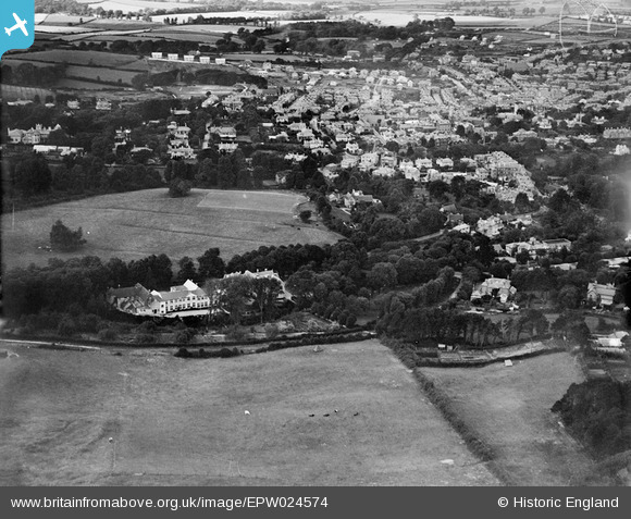
EPW024574 ENGLAND (1928). Upper Chine House and the town, Shanklin, 1928
© Copyright OpenStreetMap contributors and licensed by the OpenStreetMap Foundation. 2026. Cartography is licensed as CC BY-SA.
Nearby Images (20)
Details
| Title | [EPW024574] Upper Chine House and the town, Shanklin, 1928 |
| Reference | EPW024574 |
| Date | September-1928 |
| Link | |
| Place name | SHANKLIN |
| Parish | SHANKLIN |
| District | |
| Country | ENGLAND |
| Easting / Northing | 458087, 80555 |
| Longitude / Latitude | -1.178774903445, 50.621219398213 |
| National Grid Reference | SZ581806 |
Pins

Richard |
Thursday 12th of March 2015 11:08:16 PM |


![[EPW024574] Upper Chine House and the town, Shanklin, 1928](http://britainfromabove.org.uk/sites/all/libraries/aerofilms-images/public/100x100/EPW/024/EPW024574.jpg)
![[EPW022905] Upper Chine Girls School, Shanklin, 1928](http://britainfromabove.org.uk/sites/all/libraries/aerofilms-images/public/100x100/EPW/022/EPW022905.jpg)
![[EPW022906] Upper Chine Girls School, Shanklin, 1928](http://britainfromabove.org.uk/sites/all/libraries/aerofilms-images/public/100x100/EPW/022/EPW022906.jpg)
![[EPW022907] Upper Chine Girls School, Shanklin, 1928](http://britainfromabove.org.uk/sites/all/libraries/aerofilms-images/public/100x100/EPW/022/EPW022907.jpg)
![[EPW022904] Upper Chine Girls School, Shanklin, 1928](http://britainfromabove.org.uk/sites/all/libraries/aerofilms-images/public/100x100/EPW/022/EPW022904.jpg)
![[EPW022909] Upper Chine Girls School, Shanklin, 1928](http://britainfromabove.org.uk/sites/all/libraries/aerofilms-images/public/100x100/EPW/022/EPW022909.jpg)
![[EPW022908] Upper Chine Girls School, Shanklin, 1928](http://britainfromabove.org.uk/sites/all/libraries/aerofilms-images/public/100x100/EPW/022/EPW022908.jpg)
![[EPW024566] Big Meade Recreation Ground and Upper Chine House, Shanklin, 1928](http://britainfromabove.org.uk/sites/all/libraries/aerofilms-images/public/100x100/EPW/024/EPW024566.jpg)
![[EPW024576] Big Meade Recreation Ground and surroundings, Shanklin, 1928](http://britainfromabove.org.uk/sites/all/libraries/aerofilms-images/public/100x100/EPW/024/EPW024576.jpg)
![[EPW024569] Big Meade Recreation Ground and environs, Shanklin, 1928](http://britainfromabove.org.uk/sites/all/libraries/aerofilms-images/public/100x100/EPW/024/EPW024569.jpg)
![[EPW024568] Big Meade Recreation Ground and environs, Shanklin, 1928](http://britainfromabove.org.uk/sites/all/libraries/aerofilms-images/public/100x100/EPW/024/EPW024568.jpg)
![[EPW024570] Big Meade Recreation Ground and environs, Shanklin, 1928](http://britainfromabove.org.uk/sites/all/libraries/aerofilms-images/public/100x100/EPW/024/EPW024570.jpg)
![[EPW024573] Big Meade Recreation Ground and Upper Chine House, Shanklin, 1928](http://britainfromabove.org.uk/sites/all/libraries/aerofilms-images/public/100x100/EPW/024/EPW024573.jpg)
![[EPW024565] Big Meade Recreation Ground, Shanklin, 1928](http://britainfromabove.org.uk/sites/all/libraries/aerofilms-images/public/100x100/EPW/024/EPW024565.jpg)
![[EPW024577] Big Meade Recreation Ground, Shanklin, 1928](http://britainfromabove.org.uk/sites/all/libraries/aerofilms-images/public/100x100/EPW/024/EPW024577.jpg)
![[EPW024571] Big Meade Recreation Ground and the town, Shanklin, 1928](http://britainfromabove.org.uk/sites/all/libraries/aerofilms-images/public/100x100/EPW/024/EPW024571.jpg)
![[EPW024575] Big Meade Recreation Ground and surroundings, Shanklin, 1928](http://britainfromabove.org.uk/sites/all/libraries/aerofilms-images/public/100x100/EPW/024/EPW024575.jpg)
![[EAW028275] The town, Shanklin, from the south, 1950](http://britainfromabove.org.uk/sites/all/libraries/aerofilms-images/public/100x100/EAW/028/EAW028275.jpg)
![[EPW024567] Big Meade Recreation Ground and the town, Shanklin, 1928](http://britainfromabove.org.uk/sites/all/libraries/aerofilms-images/public/100x100/EPW/024/EPW024567.jpg)
![[EPW024572] Big Meade Recreation Ground and surroundings, Shanklin, 1928](http://britainfromabove.org.uk/sites/all/libraries/aerofilms-images/public/100x100/EPW/024/EPW024572.jpg)