
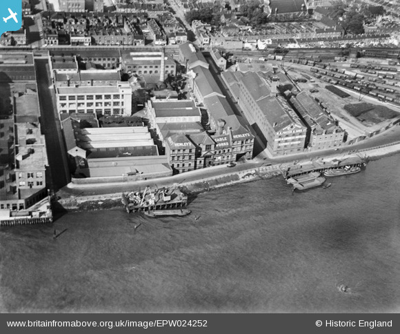
EPW024252 ENGLAND (1928). Henley's Cable Works and environs, North Woolwich, 1928
© Copyright OpenStreetMap contributors and licensed by the OpenStreetMap Foundation. 2026. Cartography is licensed as CC BY-SA.
Nearby Images (30)
EPW024252

EPW006145

EPW036585

EAW005318

EAW005313

EPW057949

EPW036584

EPW057948

EPW036583

EAW008315

EPW036586

EPW008295

EPW050840

EPW057947

EPW057950

EPW050842

EAW005312

EPW050841

EAW005310

EAW005317

EAW008316

EAW005311

EAW005315

EPW050843

EPW057953

EPW050844

EAW005316

EAW005319

EPW057954

EAW005314

Details
| Title | [EPW024252] Henley's Cable Works and environs, North Woolwich, 1928 |
| Reference | EPW024252 |
| Date | October-1928 |
| Link | |
| Place name | NORTH WOOLWICH |
| Parish | |
| District | |
| Country | ENGLAND |
| Easting / Northing | 543002, 179758 |
| Longitude / Latitude | 0.060383876651806, 51.498164645055 |
| National Grid Reference | TQ430798 |
Pins

MB |
Friday 14th of September 2012 11:18:40 PM | |
|
MB |
Friday 14th of September 2012 11:17:17 PM | |
I have an early 20th Century London atlas, as well as a modern one; they both refer to this as "Henley Road" |
John W |
Monday 2nd of May 2016 05:19:12 PM |
|
MB |
Friday 14th of September 2012 11:16:57 PM | |
|
MB |
Friday 14th of September 2012 11:15:20 PM | |
|
MB |
Friday 14th of September 2012 11:14:43 PM | |
|
MB |
Friday 14th of September 2012 11:14:06 PM | |
|
MB |
Friday 14th of September 2012 11:13:32 PM | |
An 1894 map in the Middleton Press's book "Branch Lines around North Woolwich" shows this labelled as "Victoria Ale Stores". |
John W |
Monday 2nd of May 2016 05:22:03 PM |
User Comment Contributions
The area was relatively undeveloped in 1869. The railway was extant - it was a branch of the Great Eastern Railway running down from Stratford via Canning Town. It terminated at North Woolwich. Henley's Cable Works was on or adjoining a site then known as 'Electric Telegraph Works' - another name for cable works, it seems |
MB |
Friday 14th of September 2012 11:28:08 PM |
This is not Henley on Thames it is the other side of London at Woolwich 50 miles away !! |
Shani |
Tuesday 26th of June 2012 09:14:56 AM |