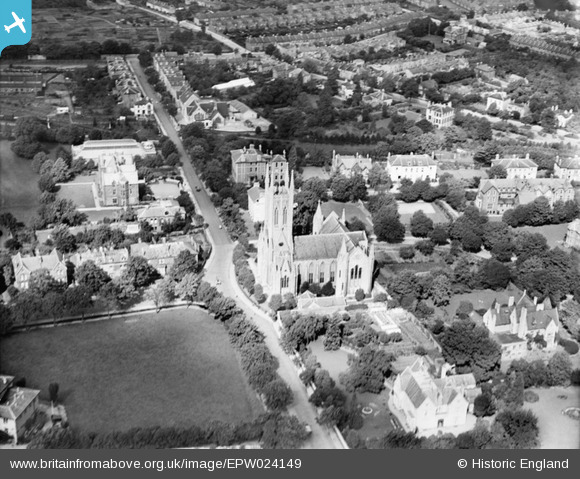
EPW024149 ENGLAND (1928). Christ Church, Cheltenham, 1928
© Copyright OpenStreetMap contributors and licensed by the OpenStreetMap Foundation. 2026. Cartography is licensed as CC BY-SA.
Nearby Images (5)
Details
| Title | [EPW024149] Christ Church, Cheltenham, 1928 |
| Reference | EPW024149 |
| Date | September-1928 |
| Link | |
| Place name | CHELTENHAM |
| Parish | |
| District | |
| Country | ENGLAND |
| Easting / Northing | 393983, 222274 |
| Longitude / Latitude | -2.0874576430973, 51.898542213865 |
| National Grid Reference | SO940223 |
Pins

Toby Clempson |
Thursday 18th of October 2012 07:17:27 AM | |

Toby Clempson |
Thursday 18th of October 2012 07:16:17 AM | |

Toby Clempson |
Thursday 18th of October 2012 07:15:08 AM | |

Class31 |
Tuesday 16th of October 2012 04:51:00 PM | |

Class31 |
Tuesday 16th of October 2012 04:50:41 PM | |

Class31 |
Tuesday 16th of October 2012 04:49:42 PM | |

Class31 |
Tuesday 16th of October 2012 04:49:10 PM | |

Class31 |
Tuesday 16th of October 2012 04:48:27 PM | |

Class31 |
Tuesday 16th of October 2012 04:48:05 PM | |

Class31 |
Tuesday 16th of October 2012 04:47:22 PM | |

Class31 |
Tuesday 16th of October 2012 04:46:36 PM | |

Class31 |
Tuesday 16th of October 2012 04:45:52 PM | |

Class31 |
Tuesday 16th of October 2012 04:45:06 PM | |

Class31 |
Tuesday 16th of October 2012 04:44:43 PM | |

AnnieP |
Sunday 5th of August 2012 10:48:19 AM | |

AnnieP |
Sunday 5th of August 2012 10:43:21 AM | |

AnnieP |
Sunday 5th of August 2012 10:41:48 AM |


![[EPW024149] Christ Church, Cheltenham, 1928](http://britainfromabove.org.uk/sites/all/libraries/aerofilms-images/public/100x100/EPW/024/EPW024149.jpg)
![[EPW024147] Christ Church, Cheltenham, 1928](http://britainfromabove.org.uk/sites/all/libraries/aerofilms-images/public/100x100/EPW/024/EPW024147.jpg)
![[EPW000164] Christ Church, Cheltenham, 1920](http://britainfromabove.org.uk/sites/all/libraries/aerofilms-images/public/100x100/EPW/000/EPW000164.jpg)
![[EPW000170] Christ Church, Cheltenham, 1920](http://britainfromabove.org.uk/sites/all/libraries/aerofilms-images/public/100x100/EPW/000/EPW000170.jpg)
![[EAW006881] Lansdown, the Ladies' College Playing Field and the town centre, Cheltenham, 1947](http://britainfromabove.org.uk/sites/all/libraries/aerofilms-images/public/100x100/EAW/006/EAW006881.jpg)