
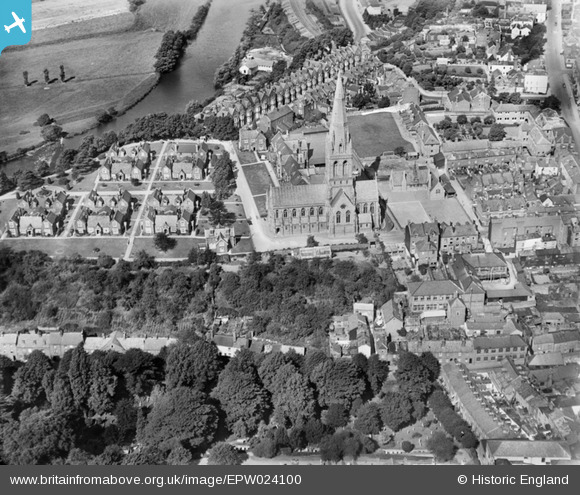
EPW024100 ENGLAND (1928). St Michael and All Angels' Church and the Free Cottages, Exeter, 1928
© Copyright OpenStreetMap contributors and licensed by the OpenStreetMap Foundation. 2026. Cartography is licensed as CC BY-SA.
Nearby Images (2)
EPW024100

EPW041168

Details
| Title | [EPW024100] St Michael and All Angels' Church and the Free Cottages, Exeter, 1928 |
| Reference | EPW024100 |
| Date | September-1928 |
| Link | |
| Place name | EXETER |
| Parish | |
| District | |
| Country | ENGLAND |
| Easting / Northing | 291565, 92691 |
| Longitude / Latitude | -3.5363866751427, 50.723139177355 |
| National Grid Reference | SX916927 |
Pins

Class31 |
Thursday 20th of June 2013 12:06:07 PM | |
|
Class31 |
Thursday 20th of June 2013 10:05:54 AM | |

DuryardDotcom |
Tuesday 11th of June 2013 10:40:52 PM | |
|
DuryardDotcom |
Tuesday 11th of June 2013 10:36:19 PM | |
Allen T |
Tuesday 2nd of October 2012 10:32:29 PM | |
Allen T |
Sunday 30th of September 2012 12:19:06 PM | |
Allen T |
Sunday 30th of September 2012 12:17:39 PM | |
Allen T |
Sunday 30th of September 2012 12:06:08 PM | |
Allen T |
Sunday 30th of September 2012 12:00:35 PM | |
Allen T |
Sunday 30th of September 2012 11:58:37 AM | |
Allen T |
Monday 24th of September 2012 04:53:14 PM | |
Allen T |
Monday 24th of September 2012 04:51:52 PM | |
|
Rob P |
Thursday 28th of June 2012 09:14:51 AM |

