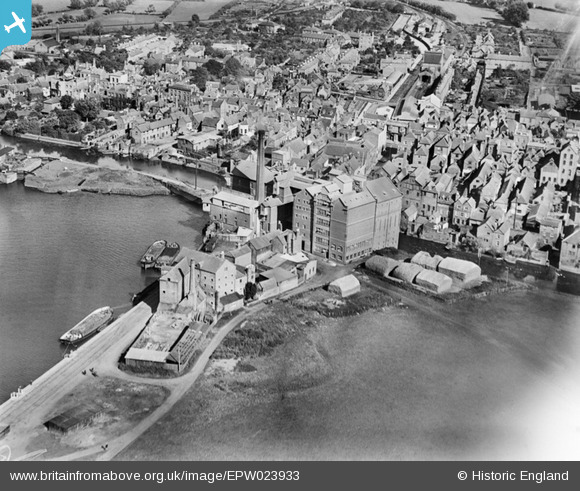
EPW023933 ENGLAND (1928). Borough Flour Mills and environs, Tewkesbury, 1928
© Copyright OpenStreetMap contributors and licensed by the OpenStreetMap Foundation. 2026. Cartography is licensed as CC BY-SA.
Details
| Title | [EPW023933] Borough Flour Mills and environs, Tewkesbury, 1928 |
| Reference | EPW023933 |
| Date | September-1928 |
| Link | |
| Place name | TEWKESBURY |
| Parish | TEWKESBURY |
| District | |
| Country | ENGLAND |
| Easting / Northing | 389206, 233005 |
| Longitude / Latitude | -2.1572285945682, 51.994961016164 |
| National Grid Reference | SO892330 |
Pins
Be the first to add a comment to this image!
User Comment Contributions
Also known as Healings Mill, I think. Barges brought grain from Sharpness and Avonmouth via the Gloucester& Sharpness Canal and the river Severn until 1998. Two of the barges belonged to the mill. It became part of the Allied Mills Ltd combine in the 1960s or 1970s and was taken over by ADM Milling of Chicago and closed with the loss of about 40 jobs in 2006 |

MB |
Wednesday 21st of September 2016 01:52:18 PM |


![[EPW023933] Borough Flour Mills and environs, Tewkesbury, 1928](http://britainfromabove.org.uk/sites/all/libraries/aerofilms-images/public/100x100/EPW/023/EPW023933.jpg)
![[EPW023935] Borough Flour Mills and environs, Tewkesbury, 1928](http://britainfromabove.org.uk/sites/all/libraries/aerofilms-images/public/100x100/EPW/023/EPW023935.jpg)
![[EAW006889] The town, Tewkesbury, 1947](http://britainfromabove.org.uk/sites/all/libraries/aerofilms-images/public/100x100/EAW/006/EAW006889.jpg)
![[EAW006890] The town, Tewkesbury, 1947](http://britainfromabove.org.uk/sites/all/libraries/aerofilms-images/public/100x100/EAW/006/EAW006890.jpg)