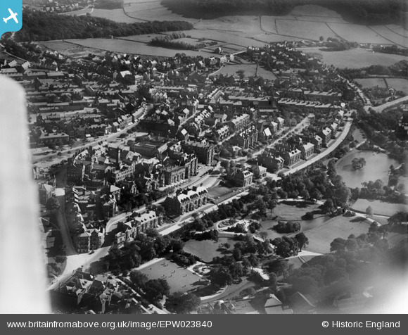
EPW023840 ENGLAND (1928). Buxton Hydro, Buxton Gardens and environs, Buxton, 1928
© Copyright OpenStreetMap contributors and licensed by the OpenStreetMap Foundation. 2026. Cartography is licensed as CC BY-SA.
Nearby Images (13)
Details
| Title | [EPW023840] Buxton Hydro, Buxton Gardens and environs, Buxton, 1928 |
| Reference | EPW023840 |
| Date | September-1928 |
| Link | |
| Place name | BUXTON |
| Parish | |
| District | |
| Country | ENGLAND |
| Easting / Northing | 405674, 373218 |
| Longitude / Latitude | -1.9149412577447, 53.255660864067 |
| National Grid Reference | SK057732 |
Pins

totoro |
Thursday 26th of July 2012 09:53:01 AM | |

totoro |
Thursday 26th of July 2012 09:52:20 AM | |

totoro |
Thursday 26th of July 2012 09:48:55 AM | |

totoro |
Thursday 26th of July 2012 09:47:14 AM | |

totoro |
Thursday 26th of July 2012 09:45:40 AM | |

totoro |
Thursday 26th of July 2012 09:44:47 AM | |

totoro |
Thursday 26th of July 2012 09:43:16 AM | |

totoro |
Thursday 26th of July 2012 09:36:56 AM | |

totoro |
Thursday 26th of July 2012 09:35:54 AM |
User Comment Contributions
This image is looking towards the South West from above the Opera House. The bulk of Buxton is behind us. The mineral baths are off to the bottom left, off picture. |

totoro |
Thursday 26th of July 2012 09:39:31 AM |


![[EPW023840] Buxton Hydro, Buxton Gardens and environs, Buxton, 1928](http://britainfromabove.org.uk/sites/all/libraries/aerofilms-images/public/100x100/EPW/023/EPW023840.jpg)
![[EPW023812] The Buxton Hydropathic Hotel and environs, Buxton, 1928](http://britainfromabove.org.uk/sites/all/libraries/aerofilms-images/public/100x100/EPW/023/EPW023812.jpg)
![[EPW023814] The Buxton Hydropathic Hotel and environs, Buxton, 1928](http://britainfromabove.org.uk/sites/all/libraries/aerofilms-images/public/100x100/EPW/023/EPW023814.jpg)
![[EPW023813] The town centre, Buxton, 1928](http://britainfromabove.org.uk/sites/all/libraries/aerofilms-images/public/100x100/EPW/023/EPW023813.jpg)
![[EPW023809] The Buxton Hydropathic Hotel and environs, Buxton, 1928](http://britainfromabove.org.uk/sites/all/libraries/aerofilms-images/public/100x100/EPW/023/EPW023809.jpg)
![[EPW023811] The Buxton Hydropathic Hotel and environs, Buxton, 1928](http://britainfromabove.org.uk/sites/all/libraries/aerofilms-images/public/100x100/EPW/023/EPW023811.jpg)
![[EPW023808] The Buxton Hydropathic Hotel and Buxton Gardens, Buxton, 1928](http://britainfromabove.org.uk/sites/all/libraries/aerofilms-images/public/100x100/EPW/023/EPW023808.jpg)
![[EPW023810] The Buxton Hydropathic Hotel and environs, Buxton, 1928](http://britainfromabove.org.uk/sites/all/libraries/aerofilms-images/public/100x100/EPW/023/EPW023810.jpg)
![[EPW023807] The Buxton Hydropathic Hotel, Buxton, 1928](http://britainfromabove.org.uk/sites/all/libraries/aerofilms-images/public/100x100/EPW/023/EPW023807.jpg)
![[EPW018995] Buxton Gardens, Buxton, 1927. This image has been produced from a damaged print.](http://britainfromabove.org.uk/sites/all/libraries/aerofilms-images/public/100x100/EPW/018/EPW018995.jpg)
![[EPW018996] The Market Place, Town Hall and environs, Buxton, 1927](http://britainfromabove.org.uk/sites/all/libraries/aerofilms-images/public/100x100/EPW/018/EPW018996.jpg)
![[EPW034112] The town and surrounding countryside, Buxton, 1930](http://britainfromabove.org.uk/sites/all/libraries/aerofilms-images/public/100x100/EPW/034/EPW034112.jpg)
![[EPW034109] Buxton Gardens, the Buxton Hydro and Higher Buxton, Buxton, 1930](http://britainfromabove.org.uk/sites/all/libraries/aerofilms-images/public/100x100/EPW/034/EPW034109.jpg)