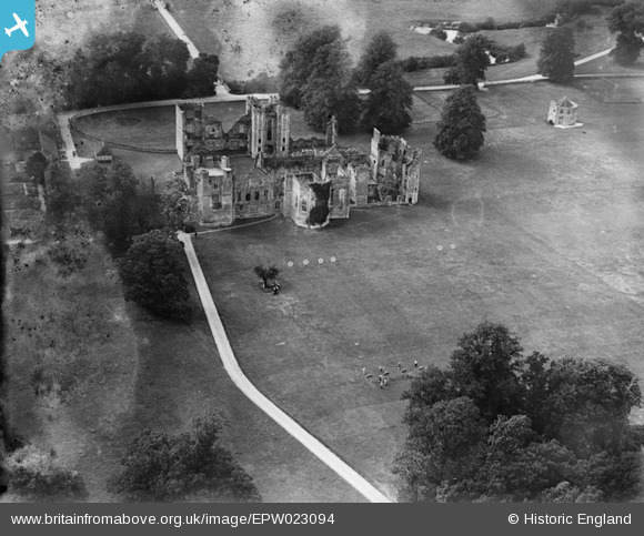
EPW023094 ENGLAND (1928). Archery at Cowdray House, Easebourne, 1928
© Copyright OpenStreetMap contributors and licensed by the OpenStreetMap Foundation. 2025. Cartography is licensed as CC BY-SA.
Nearby Images (7)
Details
| Title | [EPW023094] Archery at Cowdray House, Easebourne, 1928 |
| Reference | EPW023094 |
| Date | 24-August-1928 |
| Link | |
| Place name | EASEBOURNE |
| Parish | EASEBOURNE |
| District | |
| Country | ENGLAND |
| Easting / Northing | 489162, 121665 |
| Longitude / Latitude | -0.72954926916165, 50.98693111604 |
| National Grid Reference | SU892217 |
Pins
Be the first to add a comment to this image!


![[EPW023094] Archery at Cowdray House, Easebourne, 1928](http://britainfromabove.org.uk/sites/all/libraries/aerofilms-images/public/100x100/EPW/023/EPW023094.jpg)
![[EPW023093] Archery at Cowdray House, Easebourne, 1928](http://britainfromabove.org.uk/sites/all/libraries/aerofilms-images/public/100x100/EPW/023/EPW023093.jpg)
![[EAW035203] The remains of Cowdray House, Easebourne, 1951. This image has been produced from a print.](http://britainfromabove.org.uk/sites/all/libraries/aerofilms-images/public/100x100/EAW/035/EAW035203.jpg)
![[EPW022929] Cowdray House, Easebourne, 1928](http://britainfromabove.org.uk/sites/all/libraries/aerofilms-images/public/100x100/EPW/022/EPW022929.jpg)
![[EAW035205] The remains of Cowdray House, Easebourne, 1951. This image has been produced from a print.](http://britainfromabove.org.uk/sites/all/libraries/aerofilms-images/public/100x100/EAW/035/EAW035205.jpg)
![[EAW035204] The remains of Cowdray House, Easebourne, 1951. This image has been produced from a print.](http://britainfromabove.org.uk/sites/all/libraries/aerofilms-images/public/100x100/EAW/035/EAW035204.jpg)
![[EAW035202] A flock of sheep in a field, Easebourne, 1951. This image has been produced from a print.](http://britainfromabove.org.uk/sites/all/libraries/aerofilms-images/public/100x100/EAW/035/EAW035202.jpg)