
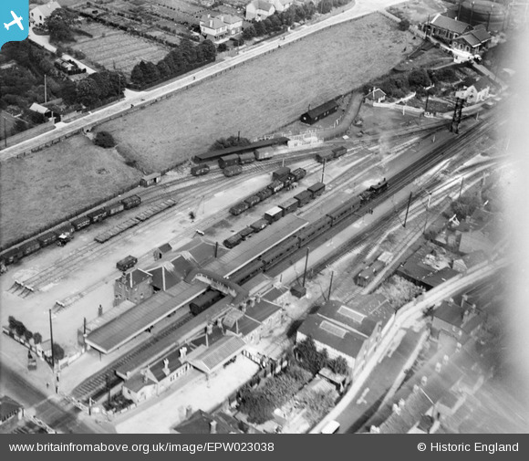
EPW023038 ENGLAND (1928). The station, Havant, 1928
© Copyright OpenStreetMap contributors and licensed by the OpenStreetMap Foundation. 2026. Cartography is licensed as CC BY-SA.
Details
| Title | [EPW023038] The station, Havant, 1928 |
| Reference | EPW023038 |
| Date | August-1928 |
| Link | |
| Place name | HAVANT |
| Parish | |
| District | |
| Country | ENGLAND |
| Easting / Northing | 471939, 106590 |
| Longitude / Latitude | -0.97788373233393, 50.853788104789 |
| National Grid Reference | SU719066 |
Pins

markypiper |
Saturday 21st of November 2015 08:44:08 PM | |
|
markypiper |
Saturday 21st of November 2015 08:44:06 PM | |
|
MB |
Tuesday 30th of October 2012 09:47:44 AM | |
|
MB |
Saturday 22nd of September 2012 10:14:25 AM | |
Maurice, I'm finding your comments very useful. Do you by any chance know where I can get a track plan for Havant station, preferably pre war. Thanks. ChrisL |
ChrisL |
Wednesday 26th of June 2013 09:00:18 PM |
|
MB |
Saturday 22nd of September 2012 10:13:28 AM | |
|
MB |
Saturday 22nd of September 2012 10:12:15 AM | |

Maurice |
Saturday 22nd of September 2012 07:19:27 AM | |
|
Maurice |
Saturday 22nd of September 2012 07:17:42 AM | |
|
Maurice |
Saturday 22nd of September 2012 07:17:01 AM | |
|
Maurice |
Saturday 22nd of September 2012 07:12:07 AM | |
|
Maurice |
Saturday 22nd of September 2012 07:08:58 AM | |
|
Maurice |
Saturday 22nd of September 2012 07:05:31 AM | |
|
Maurice |
Saturday 22nd of September 2012 06:58:30 AM |
User Comment Contributions
Nice photo of Havant Station. |
John Russell |
Saturday 22nd of September 2012 11:19:21 PM |
Additional comments on picture in main collection 22/09/12 |
Maurice |
Saturday 22nd of September 2012 11:19:21 PM |